Noyarey geodata
Noyarey (Auvergne-Rhône-Alpes) is a populated place; located in France in Europe/Paris (GMT+2) time zone. With population of 2,365 people, there are 4085 cities with bigger population in this country. Compared to other cities in France, 77% of cities are located further ↑North; 84% of cities are located further ←West and 66.1% of cities have lower elevation than Noyarey. Note1
Administrative division(s):
- Level 1: Auvergne-Rhône-Alpes
- Level 2: Département de l'Isère
- Level 3: Arrondissement de Grenoble
- Level 4: Noyarey


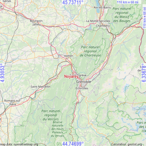
Noyarey GPS coordinates[2]
45° 14' 39.156" North, 5° 38' 1.176" East
| Map corner | latitude | longitude |
|---|---|---|
| Upper-left | 45.73711°, | 4.93053° |
| Center: | 45.24421°, | 5.63366° |
| Lower-right: | 44.74699°, | 6.33678° |
| Map W x H: | 110.1×110.1 km | = 68.4×68.4mi |
| max Lat: | 51.07786° ⇑77% North |
| Noyarey: | 45.24421° |
| min Lat: | ⇓23% South 41.3874° |
| min Long | Noyarey | max Long |
| -5.08615° | 5.63366° | 9.52242° |
| W 84%⇐ | ⇒16% E |
Elevation
Elevation of Noyarey is 199 m = 653 ft, and this is 5.3 m = 17 ft above average elevation for this country.
| Max E: |
2333 m = 7654 ft | 33.9% |
| Noyarey | 199 m 653 ft | |
| Avg. | 193.7 m = 635 ft | |
Min E: |
-1 m = -3 ft | 66.1% |
See also: France elevation on elevation.city.
Geographical zone
Noyarey is located in North temperate zone (between Tropic of Cancer and the Arctic Circle). Distance of this North polar circle is 2370.5 km =1473 mi to North.| Distance of | km | miles | from Noyarey |
|---|---|---|---|
| North Pole | 4976.4 | 3092.2 | to North |
| Arctic Circle | 2370.5 | 1473 | to North |
| Tropic Cancer | 2424.8 | 1506.7 | to South |
| Equator | 5030.7 | 3125.9 | to South |


Nearby cities:
15 places around Noyarey: (largest is in red/bold)
• Fontaine
7.1 km =4.4 mi,  143°
143°
• Fontanil-Cornillon
2.5 km =1.6 mi,  67°
67°
• Grenoble
9.7 km =6 mi, 138°
• Montaud
6.1 km =3.8 mi,  289°
289°
• Pommiers-la-Placette
8.5 km =5.3 mi,  12°
12°
• Proveysieux
5.3 km =3.3 mi, 70°
• Quaix-en-Chartreuse
6.5 km =4 mi,  84°
84°
• Saint-Martin-le-Vinoux
7.9 km =4.9 mi,  125°
125°
• Saint-Nizier-du-Moucherotte
8.1 km =5 mi,  181°
181°
• Saint-Quentin-sur-Isère
7.9 km =4.9 mi,  298°
298°
• Saint-Égrève
3.9 km =2.4 mi,  108°
108°
• Sassenage
4.2 km =2.6 mi,  146°
146°
• Seyssinet-Pariset
8.9 km =5.5 mi, 147°
• Veurey-Voroize
3.5 km =2.2 mi,  333°
333°
• Voreppe
5.6 km =3.5 mi,  358°
358°
Sources, notices
• [Note1] Compared only with cities in France existing in our database
• [Src1] Map data: © OpenStreetMap contributors (CC-BY-SA)
• [Src2] Other city data from geonames.org with taken over terms of usage.
• [Src3] Geographical zone / Annual Mean Temperature by Robert A. Rohde @ Wikipedia
