Pommiers-la-Placette geodata
Pommiers-la-Placette (Auvergne-Rhône-Alpes) is a populated place; located in France in Europe/Paris (GMT+2) time zone. With population of 632 people, there are 12784 cities with bigger population in this country. Compared to other cities in France, 76.1% of cities are located further ↑North; 84.1% of cities are located further ←West and 93.2% of cities have lower elevation than Pommiers-la-Placette. Note1
Administrative division(s):
- Level 1: Auvergne-Rhône-Alpes
- Level 2: Département de l'Isère
- Level 3: Arrondissement de Grenoble
- Level 4: La Sure en Chartreuse


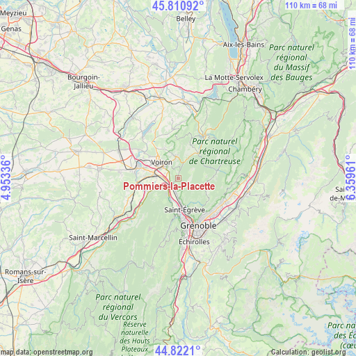
Pommiers-la-Placette GPS coordinates[2]
45° 19' 7.212" North, 5° 39' 23.364" East
| Map corner | latitude | longitude |
|---|---|---|
| Upper-left | 45.81092°, | 4.95336° |
| Center: | 45.31867°, | 5.65649° |
| Lower-right: | 44.8221°, | 6.35961° |
| Map W x H: | 109.9×109.9 km | = 68.3×68.3mi |
| max Lat: | 51.07786° ⇑76.1% North |
| Pommiers-la-Placette: | 45.31867° |
| min Lat: | ⇓23.9% South 41.3874° |
| min Long | Pommiers-la-Pla | max Long |
| -5.08615° | 5.65649° | 9.52242° |
| W 84.1%⇐ | ⇒15.9% E |
Elevation
Elevation of Pommiers-la-Placette is 512 m = 1680 ft, and this is 318.3 m = 1044 ft above average elevation for this country.
| Max E: |
2333 m = 7654 ft | 6.8% |
| Pommiers-la-Placette | 512 m 1680 ft | |
| Avg. | 193.7 m = 635 ft | |
Min E: |
-1 m = -3 ft | 93.2% |
See also: France elevation on elevation.city.
Geographical zone
Pommiers-la-Placette is located in North temperate zone (between Tropic of Cancer and the Arctic Circle). Distance of this North polar circle is 2362.2 km =1467.8 mi to North.| Distance of | km | miles | from Pommiers-la-Placette |
|---|---|---|---|
| North Pole | 4968.1 | 3087 | to North |
| Arctic Circle | 2362.2 | 1467.8 | to North |
| Tropic Cancer | 2433 | 1511.8 | to South |
| Equator | 5039 | 3131.1 | to South |


Nearby cities:
15 places around Pommiers-la-Placette: (largest is in red/bold)
• Coublevie
5.7 km =3.5 mi,  321°
321°
• Fontanil-Cornillon
7.3 km =4.5 mi,  175°
175°
• La Buisse
4.5 km =2.8 mi,  313°
313°
• Moirans
8.1 km =5 mi,  280°
280°
• Noyarey
8.5 km =5.3 mi,  192°
192°
• Proveysieux
7.2 km =4.5 mi,  153°
153°
• Quaix-en-Chartreuse
9 km =5.6 mi, 148°
• Saint-Aupre
9.4 km =5.8 mi,  4°
4°
• Saint-Cassien
9.5 km =5.9 mi,  296°
296°
• Saint-Jean-de-Moirans
6.3 km =3.9 mi, 297°
• Saint-Joseph-de-Rivière
7.1 km =4.4 mi,  26°
26°
• Saint-Étienne-de-Crossey
6.9 km =4.3 mi,  351°
351°
• Veurey-Voroize
6.1 km =3.8 mi,  213°
213°
• Voiron
7.5 km =4.7 mi, 312°
• Voreppe
3.3 km =2.1 mi,  215°
215°
Sources, notices
• [Note1] Compared only with cities in France existing in our database
• [Src1] Map data: © OpenStreetMap contributors (CC-BY-SA)
• [Src2] Other city data from geonames.org with taken over terms of usage.
• [Src3] Geographical zone / Annual Mean Temperature by Robert A. Rohde @ Wikipedia
