Saint-Égrève geodata
Saint-Égrève (Auvergne-Rhône-Alpes) is a populated place; located in France in Europe/Paris (GMT+2) time zone. With population of 15,904 people, there are 602 cities with bigger population in this country. Compared to other cities in France, 77.1% of cities are located further ↑North; 84.2% of cities are located further ←West and 69% of cities have lower elevation than Saint-Égrève. Note1
Administrative division(s):
- Level 1: Auvergne-Rhône-Alpes
- Level 2: Département de l'Isère
- Level 3: Arrondissement de Grenoble
- Level 4: Saint-Égrève


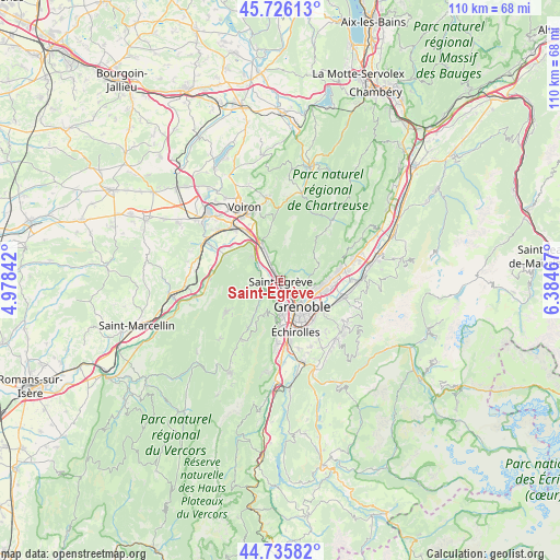
Saint-Égrève GPS coordinates[2]
45° 13' 59.268" North, 5° 40' 53.544" East
| Map corner | latitude | longitude |
|---|---|---|
| Upper-left | 45.72613°, | 4.97842° |
| Center: | 45.23313°, | 5.68154° |
| Lower-right: | 44.73582°, | 6.38467° |
| Map W x H: | 110.1×110.1 km | = 68.4×68.4mi |
| max Lat: | 51.07786° ⇑77.1% North |
| Saint-Égrève: | 45.23313° |
| min Lat: | ⇓22.9% South 41.3874° |
| min Long | Saint-Égrève | max Long |
| -5.08615° | 5.68154° | 9.52242° |
| W 84.2%⇐ | ⇒15.8% E |
Elevation
Elevation of Saint-Égrève is 214 m = 702 ft, and this is 20.3 m = 67 ft above average elevation for this country.
| Max E: |
2333 m = 7654 ft | 31% |
| Saint-Égrève | 214 m 702 ft | |
| Avg. | 193.7 m = 635 ft | |
Min E: |
-1 m = -3 ft | 69% |
See also: France elevation on elevation.city.
Geographical zone
Saint-Égrève is located in North temperate zone (between Tropic of Cancer and the Arctic Circle). Distance of this North polar circle is 2371.7 km =1473.7 mi to North.| Distance of | km | miles | from Saint-Égrève |
|---|---|---|---|
| North Pole | 4977.6 | 3092.9 | to North |
| Arctic Circle | 2371.7 | 1473.7 | to North |
| Tropic Cancer | 2423.5 | 1505.9 | to South |
| Equator | 5029.5 | 3125.2 | to South |


Nearby cities:
15 places around Saint-Égrève: (largest is in red/bold)
• Corenc
6.7 km =4.2 mi,  103°
103°
• Fontaine
4.5 km =2.8 mi,  173°
173°
• Fontanil-Cornillon
2.6 km =1.6 mi,  326°
326°
• Grenoble
6.6 km =4.1 mi,  156°
156°
• La Tronche
6 km =3.7 mi,  121°
121°
• Le Sappey-en-Chartreuse
8 km =5 mi,  66°
66°
• Noyarey
3.9 km =2.4 mi,  288°
288°
• Proveysieux
3.3 km =2.1 mi,  21°
21°
• Quaix-en-Chartreuse
3.3 km =2.1 mi,  55°
55°
• Saint-Martin-le-Vinoux
4.3 km =2.7 mi,  140°
140°
• Sassenage
2.7 km =1.7 mi,  212°
212°
• Seyssinet-Pariset
6.3 km =3.9 mi, 171°
• Seyssins
7.9 km =4.9 mi,  177°
177°
• Veurey-Voroize
6.9 km =4.3 mi,  309°
309°
• Voreppe
7.9 km =4.9 mi, 330°
In other languages:
- In Spanish: San Egreve
- In France: Saint-Égrève, Sainte-Égrève
- In Russian: Сент-Эгрев
- In Chinese: 圣埃格雷夫
Sources, notices
• [Note1] Compared only with cities in France existing in our database
• [Src1] Map data: © OpenStreetMap contributors (CC-BY-SA)
• [Src2] Other city data from geonames.org with taken over terms of usage.
• [Src3] Geographical zone / Annual Mean Temperature by Robert A. Rohde @ Wikipedia
