Volonne geodata
Volonne (Provence-Alpes-Côte d'Azur) is a populated place; located in France in Europe/Paris (GMT+2) time zone. With population of 1,612 people, there are 5797 cities with bigger population in this country. Compared to other cities in France, 86.1% of cities are located further ↑North; 87.2% of cities are located further ←West and 91.2% of cities have lower elevation than Volonne. Note1
Administrative division(s):
- Level 1: Provence-Alpes-Côte d'Azur
- Level 2: Alpes-de-Haute-Provence
- Level 3: Arrondissement de Digne-les-Bains
- Level 4: Volonne


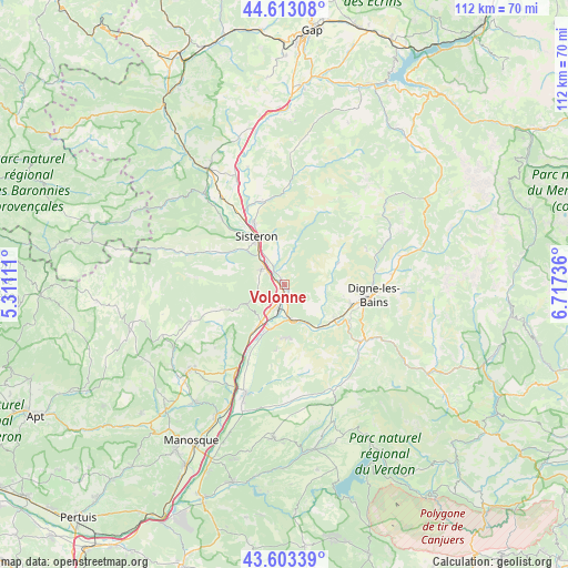
Volonne GPS coordinates[2]
44° 6' 37.404" North, 6° 0' 51.264" East
| Map corner | latitude | longitude |
|---|---|---|
| Upper-left | 44.61308°, | 5.31111° |
| Center: | 44.11039°, | 6.01424° |
| Lower-right: | 43.60339°, | 6.71736° |
| Map W x H: | 112.3×112.3 km | = 69.8×69.8mi |
| max Lat: | 51.07786° ⇑86.1% North |
| Volonne: | 44.11039° |
| min Lat: | ⇓13.9% South 41.3874° |
| min Long | Volonne | max Long |
| -5.08615° | 6.01424° | 9.52242° |
| W 87.2%⇐ | ⇒12.8% E |
Elevation
Elevation of Volonne is 454 m = 1490 ft, and this is 260.3 m = 854 ft above average elevation for this country.
| Max E: |
2333 m = 7654 ft | 8.8% |
| Volonne | 454 m 1490 ft | |
| Avg. | 193.7 m = 635 ft | |
Min E: |
-1 m = -3 ft | 91.2% |
See also: France elevation on elevation.city.
Geographical zone
Volonne is located in North temperate zone (between Tropic of Cancer and the Arctic Circle). Distance of this Northern Tropic circle is 2298.7 km =1428.3 mi to South.| Distance of | km | miles | from Volonne |
|---|---|---|---|
| North Pole | 5102.4 | 3170.5 | to North |
| Arctic Circle | 2496.6 | 1551.3 | to North |
| Tropic Cancer | 2298.7 | 1428.3 | to South |
| Equator | 4904.6 | 3047.6 | to South |


Nearby cities:
15 places around Volonne: (largest is in red/bold)
• Aubignosc
4.2 km =2.6 mi,  300°
300°
• Champtercier
11.9 km =7.4 mi,  98°
98°
• Cruis
15.2 km =9.4 mi,  249°
249°
• Digne-les-Bains
17.5 km =10.9 mi, 96°
• Les Mées
9.5 km =5.9 mi,  198°
198°
• L’Escale
3.3 km =2.1 mi,  166°
166°
• Malijai
7.3 km =4.5 mi, 169°
• Mallemoisson
11.4 km =7.1 mi,  128°
128°
• Mézel
19.3 km =12 mi, 131°
• Peipin
5.5 km =3.4 mi, 303°
• Peyruis
10.8 km =6.7 mi,  213°
213°
• Ribiers
18.4 km =11.4 mi,  316°
316°
• Saint-Étienne-les-Orgues
20.1 km =12.5 mi, 248°
• Sisteron
10.4 km =6.5 mi,  328°
328°
• Thoard
11.5 km =7.1 mi,  67°
67°
Sources, notices
• [Note1] Compared only with cities in France existing in our database
• [Src1] Map data: © OpenStreetMap contributors (CC-BY-SA)
• [Src2] Other city data from geonames.org with taken over terms of usage.
• [Src3] Geographical zone / Annual Mean Temperature by Robert A. Rohde @ Wikipedia
