Aubignosc geodata
Aubignosc (Provence-Alpes-Côte d'Azur) is a populated place; located in France in Europe/Paris (GMT+2) time zone. With population of 556 people, there are 14098 cities with bigger population in this country. Compared to other cities in France, 86% of cities are located further ↑North; 86.7% of cities are located further ←West and 92.5% of cities have lower elevation than Aubignosc. Note1
Administrative division(s):
- Level 1: Provence-Alpes-Côte d'Azur
- Level 2: Alpes-de-Haute-Provence
- Level 3: Arrondissement de Forcalquier
- Level 4: Aubignosc


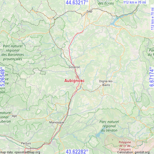
Aubignosc GPS coordinates[2]
44° 7' 46.74" North, 5° 58' 6.996" East
| Map corner | latitude | longitude |
|---|---|---|
| Upper-left | 44.63217°, | 5.26549° |
| Center: | 44.12965°, | 5.96861° |
| Lower-right: | 43.62282°, | 6.67174° |
| Map W x H: | 112.2×112.2 km | = 69.7×69.7mi |
| max Lat: | 51.07786° ⇑86% North |
| Aubignosc: | 44.12965° |
| min Lat: | ⇓14% South 41.3874° |
| min Long | Aubignosc | max Long |
| -5.08615° | 5.96861° | 9.52242° |
| W 86.7%⇐ | ⇒13.3% E |
Elevation
Elevation of Aubignosc is 488 m = 1601 ft, and this is 294.3 m = 966 ft above average elevation for this country.
| Max E: |
2333 m = 7654 ft | 7.5% |
| Aubignosc | 488 m 1601 ft | |
| Avg. | 193.7 m = 635 ft | |
Min E: |
-1 m = -3 ft | 92.5% |
See also: France elevation on elevation.city.
Geographical zone
Aubignosc is located in North temperate zone (between Tropic of Cancer and the Arctic Circle). Distance of this Northern Tropic circle is 2300.8 km =1429.7 mi to South.| Distance of | km | miles | from Aubignosc |
|---|---|---|---|
| North Pole | 5100.3 | 3169.2 | to North |
| Arctic Circle | 2494.4 | 1549.9 | to North |
| Tropic Cancer | 2300.8 | 1429.7 | to South |
| Equator | 4906.8 | 3048.9 | to South |


Nearby cities:
15 places around Aubignosc: (largest is in red/bold)
• Champtercier
15.9 km =9.9 mi,  103°
103°
• Cruis
13 km =8.1 mi,  234°
234°
• Digne-les-Bains
21.4 km =13.3 mi, 101°
• Les Mées
11.1 km =6.9 mi,  176°
176°
• L’Escale
6.9 km =4.3 mi,  140°
140°
• Malijai
10.5 km =6.5 mi,  152°
152°
• Mallemoisson
15.6 km =9.7 mi,  126°
126°
• Mison
18.2 km =11.3 mi,  325°
325°
• Peipin
1.3 km =0.8 mi,  314°
314°
• Peyruis
11.4 km =7.1 mi,  191°
191°
• Ribiers
14.4 km =8.9 mi,  321°
321°
• Saint-Étienne-les-Orgues
17.8 km =11.1 mi,  238°
238°
• Sisteron
6.9 km =4.3 mi,  345°
345°
• Thoard
14.5 km =9 mi,  81°
81°
• Volonne
4.2 km =2.6 mi,  120°
120°
Sources, notices
• [Note1] Compared only with cities in France existing in our database
• [Src1] Map data: © OpenStreetMap contributors (CC-BY-SA)
• [Src2] Other city data from geonames.org with taken over terms of usage.
• [Src3] Geographical zone / Annual Mean Temperature by Robert A. Rohde @ Wikipedia
