Pierrelatte geodata
Pierrelatte (Auvergne-Rhône-Alpes) is a populated place; located in France in Europe/Paris (GMT+2) time zone. With population of 12,691 people, there are 745 cities with bigger population in this country. Compared to other cities in France, 84.4% of cities are located further ↑North; 73.8% of cities are located further ←West and 79.8% of cities have higher elevation than Pierrelatte. Note1
Administrative division(s):
- Level 1: Auvergne-Rhône-Alpes
- Level 2: Département de la Drôme
- Level 3: Arrondissement de Nyons
- Level 4: Pierrelatte


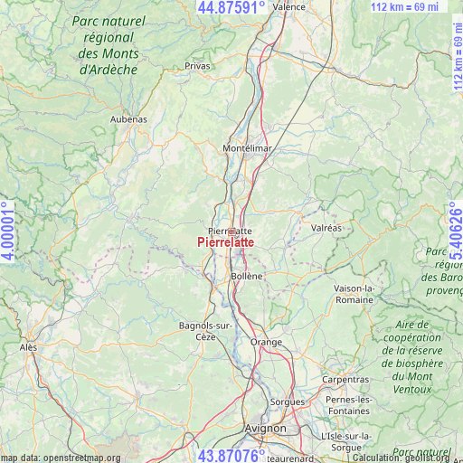
Pierrelatte GPS coordinates[2]
44° 22' 31.764" North, 4° 42' 11.304" East
| Map corner | latitude | longitude |
|---|---|---|
| Upper-left | 44.87591°, | 4.00001° |
| Center: | 44.37549°, | 4.70314° |
| Lower-right: | 43.87076°, | 5.40626° |
| Map W x H: | 111.8×111.8 km | = 69.5×69.5mi |
| max Lat: | 51.07786° ⇑84.4% North |
| Pierrelatte: | 44.37549° |
| min Lat: | ⇓15.6% South 41.3874° |
| min Long | Pierrelatte | max Long |
| -5.08615° | 4.70314° | 9.52242° |
| W 73.8%⇐ | ⇒26.2% E |
Elevation
Elevation of Pierrelatte is 55 m = 180 ft, and this is 138.7 m = 455 ft below average elevation for this country.
| Max E: |
2333 m = 7654 ft | 79.8% |
| Avg. | 193.7 m = 635 ft | |
| Pierrelatte | 55 m = 180 ft | |
Min E: |
-1 m = -3 ft | 20.2% |
See also: France elevation on elevation.city.
Geographical zone
Pierrelatte is located in North temperate zone (between Tropic of Cancer and the Arctic Circle). Distance of this Northern Tropic circle is 2328.2 km =1446.7 mi to South.| Distance of | km | miles | from Pierrelatte |
|---|---|---|---|
| North Pole | 5073 | 3152.2 | to North |
| Arctic Circle | 2467.1 | 1533 | to North |
| Tropic Cancer | 2328.2 | 1446.7 | to South |
| Equator | 4934.1 | 3065.9 | to South |


Nearby cities:
15 places around Pierrelatte: (largest is in red/bold)
• Bollène
11.1 km =6.9 mi,  160°
160°
• Bourg-Saint-Andéol
4.7 km =2.9 mi,  267°
267°
• Châteauneuf-du-Rhône
12.7 km =7.9 mi,  5°
5°
• Donzère
7.5 km =4.7 mi,  4°
4°
• La Garde-Adhémar
4.9 km =3 mi,  61°
61°
• Lapalud
7.6 km =4.7 mi,  188°
188°
• Les Granges-Gontardes
6.7 km =4.2 mi,  46°
46°
• Malataverne
12.8 km =8 mi,  18°
18°
• Montségur-sur-Lauzon
12.2 km =7.6 mi,  97°
97°
• Saint-Just-d'Ardèche
10.9 km =6.8 mi,  219°
219°
• Saint-Marcel-d'Ardèche
8.7 km =5.4 mi,  231°
231°
• Saint-Paul-Trois-Châteaux
5.8 km =3.6 mi,  124°
124°
• Saint-Restitut
9.1 km =5.7 mi,  128°
128°
• Valaurie
10.1 km =6.3 mi, 57°
• Viviers
12 km =7.5 mi,  354°
354°
Sources, notices
• [Note1] Compared only with cities in France existing in our database
• [Src1] Map data: © OpenStreetMap contributors (CC-BY-SA)
• [Src2] Other city data from geonames.org with taken over terms of usage.
• [Src3] Geographical zone / Annual Mean Temperature by Robert A. Rohde @ Wikipedia
