Vitrac geodata
Vitrac (Nouvelle-Aquitaine) is a populated place; located in France in Europe/Paris (GMT+2) time zone. With population of 807 people, there are 10522 cities with bigger population in this country. Compared to other cities in France, 81.1% of cities are located further ↑North; 66.1% of cities are located further →East and 59.4% of cities have higher elevation than Vitrac. Note1
Administrative division(s):
- Level 1: Nouvelle-Aquitaine
- Level 2: Dordogne
- Level 3: Arrondissement de Sarlat-la-Canéda
- Level 4: Vitrac


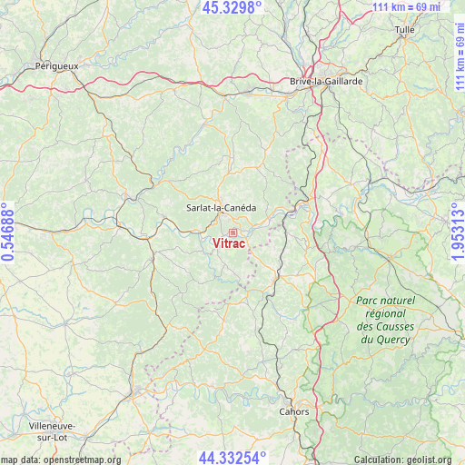
Vitrac GPS coordinates[2]
44° 49' 59.988" North, 1° 15' 0" East
| Map corner | latitude | longitude |
|---|---|---|
| Upper-left | 45.3298°, | 0.54688° |
| Center: | 44.83333°, | 1.25° |
| Lower-right: | 44.33254°, | 1.95313° |
| Map W x H: | 110.9×110.9 km | = 68.9×68.9mi |
| max Lat: | 51.07786° ⇑81.1% North |
| Vitrac: | 44.83333° |
| min Lat: | ⇓18.9% South 41.3874° |
| min Long | Vitrac | max Long |
| -5.08615° | 1.25° | 9.52242° |
| W 33.9%⇐ | ⇒66.1% E |
Elevation
Elevation of Vitrac is 104 m = 341 ft, and this is 89.7 m = 294 ft below average elevation for this country.
| Max E: |
2333 m = 7654 ft | 59.4% |
| Avg. | 193.7 m = 635 ft | |
| Vitrac | 104 m = 341 ft | |
Min E: |
-1 m = -3 ft | 40.6% |
See also: France elevation on elevation.city.
Geographical zone
Vitrac is located in North temperate zone (between Tropic of Cancer and the Arctic Circle). Distance of this Northern Tropic circle is 2379.1 km =1478.3 mi to South.| Distance of | km | miles | from Vitrac |
|---|---|---|---|
| North Pole | 5022.1 | 3120.6 | to North |
| Arctic Circle | 2416.2 | 1501.4 | to North |
| Tropic Cancer | 2379.1 | 1478.3 | to South |
| Equator | 4985 | 3097.5 | to South |


Nearby cities:
15 places around Vitrac: (largest is in red/bold)
• Beynac-et-Cazenac
8.4 km =5.2 mi,  274°
274°
• Carlux
9.6 km =6 mi,  54°
54°
• Carsac-Aillac
0 km =0 mi,  0°
0°
• Cénac-et-Saint-Julien
5.1 km =3.2 mi,  223°
223°
• Daglan
11.1 km =6.9 mi,  204°
204°
• Domme
4.4 km =2.7 mi, 218°
• Eyvigues-et-Eybènes
13.6 km =8.5 mi,  35°
35°
• Groléjac
3.6 km =2.2 mi,  114°
114°
• Marcillac-Saint-Quentin
14.9 km =9.3 mi,  354°
354°
• Payrignac
11.8 km =7.3 mi,  137°
137°
• Proissans
11.2 km =7 mi, 353°
• Saint-Julien-de-Lampon
8.7 km =5.4 mi,  64°
64°
• Saint-Martial-de-Nabirat
9.9 km =6.2 mi,  176°
176°
• Sarlat-la-Canéda
6.7 km =4.2 mi,  336°
336°
• Vézac
6.8 km =4.2 mi, 270°
Sources, notices
• [Note1] Compared only with cities in France existing in our database
• [Src1] Map data: © OpenStreetMap contributors (CC-BY-SA)
• [Src2] Other city data from geonames.org with taken over terms of usage.
• [Src3] Geographical zone / Annual Mean Temperature by Robert A. Rohde @ Wikipedia
