Domme geodata
Domme (Nouvelle-Aquitaine) is a populated place; located in France in Europe/Paris (GMT+2) time zone. With population of 1,013 people, there are 8749 cities with bigger population in this country. Compared to other cities in France, 81.4% of cities are located further ↑North; 66.6% of cities are located further →East and 68.5% of cities have lower elevation than Domme. Note1
Administrative division(s):
- Level 1: Nouvelle-Aquitaine
- Level 2: Dordogne
- Level 3: Arrondissement de Sarlat-la-Canéda
- Level 4: Domme


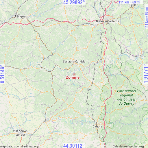
Domme GPS coordinates[2]
44° 48' 7.848" North, 1° 12' 52.524" East
| Map corner | latitude | longitude |
|---|---|---|
| Upper-left | 45.29892°, | 0.51146° |
| Center: | 44.80218°, | 1.21459° |
| Lower-right: | 44.30112°, | 1.91771° |
| Map W x H: | 110.9×110.9 km | = 68.9×68.9mi |
| max Lat: | 51.07786° ⇑81.4% North |
| Domme: | 44.80218° |
| min Lat: | ⇓18.6% South 41.3874° |
| min Long | Domme | max Long |
| -5.08615° | 1.21459° | 9.52242° |
| W 33.4%⇐ | ⇒66.6% E |
Elevation
Elevation of Domme is 211 m = 692 ft, and this is 17.3 m = 57 ft above average elevation for this country.
| Max E: |
2333 m = 7654 ft | 31.5% |
| Domme | 211 m 692 ft | |
| Avg. | 193.7 m = 635 ft | |
Min E: |
-1 m = -3 ft | 68.5% |
See also: France elevation on elevation.city.
Geographical zone
Domme is located in North temperate zone (between Tropic of Cancer and the Arctic Circle). Distance of this Northern Tropic circle is 2375.6 km =1476.1 mi to South.| Distance of | km | miles | from Domme |
|---|---|---|---|
| North Pole | 5025.5 | 3122.7 | to North |
| Arctic Circle | 2419.6 | 1503.5 | to North |
| Tropic Cancer | 2375.6 | 1476.1 | to South |
| Equator | 4981.5 | 3095.4 | to South |


Nearby cities:
15 places around Domme: (largest is in red/bold)
• Beynac-et-Cazenac
7 km =4.3 mi,  306°
306°
• Carlux
14 km =8.7 mi,  49°
49°
• Carsac-Aillac
4.4 km =2.7 mi,  38°
38°
• Cénac-et-Saint-Julien
0.8 km =0.5 mi,  249°
249°
• Daglan
6.9 km =4.3 mi,  194°
194°
• Gourdon
15.1 km =9.4 mi,  118°
118°
• Groléjac
6.4 km =4 mi,  72°
72°
• Payrignac
12 km =7.5 mi, 115°
• Proissans
14.7 km =9.1 mi,  5°
5°
• Saint-Julien-de-Lampon
12.9 km =8 mi,  56°
56°
• Saint-Martial-de-Nabirat
7.3 km =4.5 mi,  151°
151°
• Salviac
14.1 km =8.8 mi,  163°
163°
• Sarlat-la-Canéda
9.7 km =6 mi,  0°
0°
• Vitrac
4.4 km =2.7 mi, 38°
• Vézac
5.3 km =3.3 mi, 311°
Sources, notices
• [Note1] Compared only with cities in France existing in our database
• [Src1] Map data: © OpenStreetMap contributors (CC-BY-SA)
• [Src2] Other city data from geonames.org with taken over terms of usage.
• [Src3] Geographical zone / Annual Mean Temperature by Robert A. Rohde @ Wikipedia
