Sarlat-la-Canéda geodata
Sarlat-la-Canéda (Nouvelle-Aquitaine) is a seat of a third-order administrative division; located in France in Europe/Paris (GMT+2) time zone. With population of 11,126 people, there are 864 cities with bigger population in this country. Compared to other cities in France, 80.6% of cities are located further ↑North; 66.6% of cities are located further →East and 54.2% of cities have lower elevation than Sarlat-la-Canéda. Note1
Administrative division(s):
- Level 1: Nouvelle-Aquitaine
- Level 2: Dordogne
- Level 3: Arrondissement de Sarlat-la-Canéda
- Level 4: Sarlat-la-Canéda


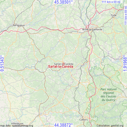
Sarlat-la-Canéda GPS coordinates[2]
44° 53' 20.472" North, 1° 12' 59.616" East
| Map corner | latitude | longitude |
|---|---|---|
| Upper-left | 45.38501°, | 0.51343° |
| Center: | 44.88902°, | 1.21656° |
| Lower-right: | 44.38872°, | 1.91968° |
| Map W x H: | 110.8×110.8 km | = 68.8×68.8mi |
| max Lat: | 51.07786° ⇑80.6% North |
| Sarlat-la-Canéda: | 44.88902° |
| min Lat: | ⇓19.4% South 41.3874° |
| min Long | Sarlat-la-Cané | max Long |
| -5.08615° | 1.21656° | 9.52242° |
| W 33.4%⇐ | ⇒66.6% E |
Elevation
Elevation of Sarlat-la-Canéda is 147 m = 482 ft, and this is 46.7 m = 153 ft below average elevation for this country.
| Max E: |
2333 m = 7654 ft | 45.8% |
| Avg. | 193.7 m = 635 ft | |
| Sarlat-la-Canéda | 147 m = 482 ft | |
Min E: |
-1 m = -3 ft | 54.2% |
See also: France elevation on elevation.city.
Geographical zone
Sarlat-la-Canéda is located in North temperate zone (between Tropic of Cancer and the Arctic Circle). Distance of this Northern Tropic circle is 2385.3 km =1482.2 mi to South.| Distance of | km | miles | from Sarlat-la-Canéda |
|---|---|---|---|
| North Pole | 5015.9 | 3116.7 | to North |
| Arctic Circle | 2410 | 1497.5 | to North |
| Tropic Cancer | 2385.3 | 1482.2 | to South |
| Equator | 4991.2 | 3101.4 | to South |


Nearby cities:
15 places around Sarlat-la-Canéda: (largest is in red/bold)
• Beynac-et-Cazenac
7.9 km =4.9 mi,  226°
226°
• Carlux
10.5 km =6.5 mi,  93°
93°
• Carsac-Aillac
6.7 km =4.2 mi,  156°
156°
• Cénac-et-Saint-Julien
10 km =6.2 mi,  185°
185°
• Domme
9.7 km =6 mi,  180°
180°
• Eyvigues-et-Eybènes
11.6 km =7.2 mi,  64°
64°
• Groléjac
9.7 km =6 mi,  142°
142°
• Marcillac-Saint-Quentin
8.7 km =5.4 mi,  8°
8°
• Marquay
8.6 km =5.3 mi,  322°
322°
• Proissans
5.1 km =3.2 mi,  15°
15°
• Saint-Geniès
12.6 km =7.8 mi, 12°
• Saint-Julien-de-Lampon
10.8 km =6.7 mi,  103°
103°
• Salignac-Eyvigues
12.7 km =7.9 mi,  41°
41°
• Vitrac
6.7 km =4.2 mi, 156°
• Vézac
7.4 km =4.6 mi,  213°
213°
Sources, notices
• [Note1] Compared only with cities in France existing in our database
• [Src1] Map data: © OpenStreetMap contributors (CC-BY-SA)
• [Src2] Other city data from geonames.org with taken over terms of usage.
• [Src3] Geographical zone / Annual Mean Temperature by Robert A. Rohde @ Wikipedia
