Beynac-et-Cazenac geodata
Beynac-et-Cazenac (Nouvelle-Aquitaine) is a populated place; located in France in Europe/Paris (GMT+2) time zone. With population of 535 people, there are 14511 cities with bigger population in this country. Compared to other cities in France, 81% of cities are located further ↑North; 67.4% of cities are located further →East and 57.6% of cities have higher elevation than Beynac-et-Cazenac. Note1
Administrative division(s):
- Level 1: Nouvelle-Aquitaine
- Level 2: Dordogne
- Level 3: Arrondissement de Sarlat-la-Canéda
- Level 4: Beynac-et-Cazenac


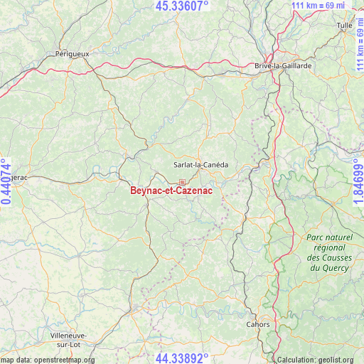
Beynac-et-Cazenac GPS coordinates[2]
44° 50' 22.74" North, 1° 8' 37.932" East
| Map corner | latitude | longitude |
|---|---|---|
| Upper-left | 45.33607°, | 0.44074° |
| Center: | 44.83965°, | 1.14387° |
| Lower-right: | 44.33892°, | 1.84699° |
| Map W x H: | 110.9×110.9 km | = 68.9×68.9mi |
| max Lat: | 51.07786° ⇑81% North |
| Beynac-et-Cazenac: | 44.83965° |
| min Lat: | ⇓19% South 41.3874° |
| min Long | Beynac-et-Cazen | max Long |
| -5.08615° | 1.14387° | 9.52242° |
| W 32.6%⇐ | ⇒67.4% E |
Elevation
Elevation of Beynac-et-Cazenac is 109 m = 358 ft, and this is 84.7 m = 278 ft below average elevation for this country.
| Max E: |
2333 m = 7654 ft | 57.6% |
| Avg. | 193.7 m = 635 ft | |
| Beynac-et-Cazenac | 109 m = 358 ft | |
Min E: |
-1 m = -3 ft | 42.4% |
See also: France elevation on elevation.city.
Geographical zone
Beynac-et-Cazenac is located in North temperate zone (between Tropic of Cancer and the Arctic Circle). Distance of this Northern Tropic circle is 2379.8 km =1478.7 mi to South.| Distance of | km | miles | from Beynac-et-Cazenac |
|---|---|---|---|
| North Pole | 5021.4 | 3120.2 | to North |
| Arctic Circle | 2415.5 | 1500.9 | to North |
| Tropic Cancer | 2379.8 | 1478.7 | to South |
| Equator | 4985.7 | 3098 | to South |


Nearby cities:
15 places around Beynac-et-Cazenac: (largest is in red/bold)
• Belvès
13 km =8.1 mi,  237°
237°
• Carsac-Aillac
8.4 km =5.2 mi,  94°
94°
• Coux-et-Bigaroque
13.5 km =8.4 mi,  267°
267°
• Cénac-et-Saint-Julien
6.6 km =4.1 mi,  132°
132°
• Daglan
11.5 km =7.1 mi,  160°
160°
• Domme
7 km =4.3 mi, 126°
• Groléjac
11.8 km =7.3 mi,  100°
100°
• Marquay
12.3 km =7.6 mi,  2°
2°
• Proissans
12.6 km =7.8 mi,  34°
34°
• Saint-Cyprien
8.7 km =5.4 mi,  292°
292°
• Saint-Martial-de-Nabirat
13.9 km =8.6 mi,  139°
139°
• Sarlat-la-Canéda
7.9 km =4.9 mi,  46°
46°
• Siorac-en-Périgord
12.5 km =7.8 mi,  260°
260°
• Vitrac
8.4 km =5.2 mi, 94°
• Vézac
1.7 km =1.1 mi,  112°
112°
Sources, notices
• [Note1] Compared only with cities in France existing in our database
• [Src1] Map data: © OpenStreetMap contributors (CC-BY-SA)
• [Src2] Other city data from geonames.org with taken over terms of usage.
• [Src3] Geographical zone / Annual Mean Temperature by Robert A. Rohde @ Wikipedia
