Viry-Noureuil geodata
Viry-Noureuil (Hauts-de-France) is a populated place; located in France in Europe/Paris (GMT+2) time zone. With population of 1,972 people, there are 4849 cities with bigger population in this country. Compared to other cities in France, 90.9% of cities are located further ↓South; 61.2% of cities are located further ←West and 80.2% of cities have higher elevation than Viry-Noureuil. Note1
Administrative division(s):
- Level 1: Hauts-de-France
- Level 2: Département de l'Aisne
- Level 3: Arrondissement de Laon
- Level 4: Viry-Noureuil


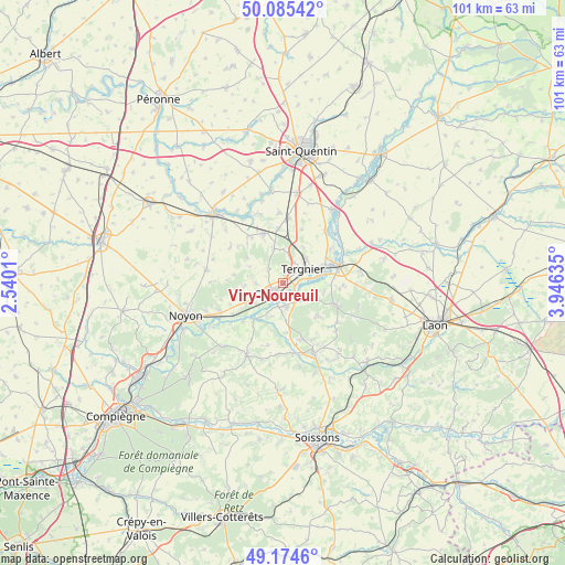
Viry-Noureuil GPS coordinates[2]
49° 37' 55.704" North, 3° 14' 35.592" East
| Map corner | latitude | longitude |
|---|---|---|
| Upper-left | 50.08542°, | 2.5401° |
| Center: | 49.63214°, | 3.24322° |
| Lower-right: | 49.1746°, | 3.94635° |
| Map W x H: | 101.3×101.3 km | = 62.9×62.9mi |
| max Lat: | 51.07786° ⇑9.1% North |
| Viry-Noureuil: | 49.63214° |
| min Lat: | ⇓90.9% South 41.3874° |
| min Long | Viry-Noureuil | max Long |
| -5.08615° | 3.24322° | 9.52242° |
| W 61.2%⇐ | ⇒38.8% E |
Elevation
Elevation of Viry-Noureuil is 54 m = 177 ft, and this is 139.7 m = 458 ft below average elevation for this country.
| Max E: |
2333 m = 7654 ft | 80.2% |
| Avg. | 193.7 m = 635 ft | |
| Viry-Noureuil | 54 m = 177 ft | |
Min E: |
-1 m = -3 ft | 19.8% |
See also: France elevation on elevation.city.
Geographical zone
Viry-Noureuil is located in North temperate zone (between Tropic of Cancer and the Arctic Circle). Distance of this North polar circle is 1882.6 km =1169.8 mi to North.| Distance of | km | miles | from Viry-Noureuil |
|---|---|---|---|
| North Pole | 4488.5 | 2789 | to North |
| Arctic Circle | 1882.6 | 1169.8 | to North |
| Tropic Cancer | 2912.7 | 1809.9 | to South |
| Equator | 5518.6 | 3429.1 | to South |


Nearby cities:
15 places around Viry-Noureuil: (largest is in red/bold)
• Amigny-Rouy
5 km =3.1 mi,  119°
119°
• Autreville
5.3 km =3.3 mi,  181°
181°
• Barisis
8.5 km =5.3 mi,  129°
129°
• Beautor
7.6 km =4.7 mi,  73°
73°
• Bichancourt
6.1 km =3.8 mi,  197°
197°
• Chauny
2.6 km =1.6 mi,  223°
223°
• Condren
2.7 km =1.7 mi,  96°
96°
• Flavy-le-Martel
9.7 km =6 mi,  337°
337°
• Frières-Faillouël
6.2 km =3.9 mi,  0°
0°
• Jussy
9.8 km =6.1 mi,  355°
355°
• La Fère
9.5 km =5.9 mi, 68°
• Ognes
4.2 km =2.6 mi,  238°
238°
• Sinceny
4 km =2.5 mi, 176°
• Tergnier
4.9 km =3 mi,  57°
57°
• Villequier-Aumont
3.9 km =2.4 mi,  316°
316°
Sources, notices
• [Note1] Compared only with cities in France existing in our database
• [Src1] Map data: © OpenStreetMap contributors (CC-BY-SA)
• [Src2] Other city data from geonames.org with taken over terms of usage.
• [Src3] Geographical zone / Annual Mean Temperature by Robert A. Rohde @ Wikipedia
