Flavy-le-Martel geodata
Flavy-le-Martel (Hauts-de-France) is a populated place; located in France in Europe/Paris (GMT+2) time zone. With population of 1,529 people, there are 6086 cities with bigger population in this country. Compared to other cities in France, 91.6% of cities are located further ↓South; 60.5% of cities are located further ←West and 73.1% of cities have higher elevation than Flavy-le-Martel. Note1
Administrative division(s):
- Level 1: Hauts-de-France
- Level 2: Département de l'Aisne
- Level 3: Arrondissement de Saint-Quentin
- Level 4: Flavy-le-Martel


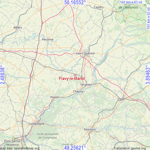
Flavy-le-Martel GPS coordinates[2]
49° 42' 46.764" North, 3° 11' 29.4" East
| Map corner | latitude | longitude |
|---|---|---|
| Upper-left | 50.16552°, | 2.48838° |
| Center: | 49.71299°, | 3.1915° |
| Lower-right: | 49.25621°, | 3.89463° |
| Map W x H: | 101.1×101.1 km | = 62.8×62.8mi |
| max Lat: | 51.07786° ⇑8.4% North |
| Flavy-le-Martel: | 49.71299° |
| min Lat: | ⇓91.6% South 41.3874° |
| min Long | Flavy-le-Martel | max Long |
| -5.08615° | 3.1915° | 9.52242° |
| W 60.5%⇐ | ⇒39.5% E |
Elevation
Elevation of Flavy-le-Martel is 71 m = 233 ft, and this is 122.7 m = 403 ft below average elevation for this country.
| Max E: |
2333 m = 7654 ft | 73.1% |
| Avg. | 193.7 m = 635 ft | |
| Flavy-le-Martel | 71 m = 233 ft | |
Min E: |
-1 m = -3 ft | 26.9% |
See also: France elevation on elevation.city.
Geographical zone
Flavy-le-Martel is located in North temperate zone (between Tropic of Cancer and the Arctic Circle). Distance of this North polar circle is 1873.6 km =1164.2 mi to North.| Distance of | km | miles | from Flavy-le-Martel |
|---|---|---|---|
| North Pole | 4479.5 | 2783.4 | to North |
| Arctic Circle | 1873.6 | 1164.2 | to North |
| Tropic Cancer | 2921.6 | 1815.4 | to South |
| Equator | 5527.6 | 3434.7 | to South |


Nearby cities:
15 places around Flavy-le-Martel: (largest is in red/bold)
• Brouchy
6.6 km =4.1 mi,  273°
273°
• Clastres
4.7 km =2.9 mi,  38°
38°
• Cugny
2.9 km =1.8 mi,  257°
257°
• Eppeville
10.5 km =6.5 mi,  286°
286°
• Essigny-le-Grand
9.6 km =6 mi, 40°
• Frières-Faillouël
4.6 km =2.9 mi,  126°
126°
• Ham
9.3 km =5.8 mi, 294°
• Jussy
3.1 km =1.9 mi,  75°
75°
• Montescourt-Lizerolles
5.5 km =3.4 mi,  59°
59°
• Muille-Villette
9 km =5.6 mi,  280°
280°
• Saint-Simon
3.8 km =2.4 mi,  344°
344°
• Seraucourt-le-Grand
8 km =5 mi,  13°
13°
• Tergnier
10.1 km =6.3 mi, 128°
• Villequier-Aumont
6.2 km =3.9 mi,  170°
170°
• Viry-Noureuil
9.7 km =6 mi,  157°
157°
Sources, notices
• [Note1] Compared only with cities in France existing in our database
• [Src1] Map data: © OpenStreetMap contributors (CC-BY-SA)
• [Src2] Other city data from geonames.org with taken over terms of usage.
• [Src3] Geographical zone / Annual Mean Temperature by Robert A. Rohde @ Wikipedia
