Barisis geodata
Barisis (Hauts-de-France) is a populated place; located in France in Europe/Paris (GMT+2) time zone. With population of 680 people, there are 12068 cities with bigger population in this country. Compared to other cities in France, 90.4% of cities are located further ↓South; 62.4% of cities are located further ←West and 67% of cities have higher elevation than Barisis. Note1
Administrative division(s):
- Level 1: Hauts-de-France
- Level 2: Département de l'Aisne
- Level 3: Arrondissement de Laon
- Level 4: Barisis-aux-Bois


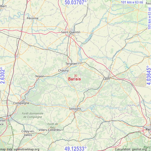
Barisis GPS coordinates[2]
49° 34' 59.988" North, 3° 19' 59.988" East
| Map corner | latitude | longitude |
|---|---|---|
| Upper-left | 50.03707°, | 2.6302° |
| Center: | 49.58333°, | 3.33333° |
| Lower-right: | 49.12533°, | 4.03645° |
| Map W x H: | 101.4×101.4 km | = 63×63mi |
| max Lat: | 51.07786° ⇑9.6% North |
| Barisis: | 49.58333° |
| min Lat: | ⇓90.4% South 41.3874° |
| min Long | Barisis | max Long |
| -5.08615° | 3.33333° | 9.52242° |
| W 62.4%⇐ | ⇒37.6% E |
Elevation
Elevation of Barisis is 85 m = 279 ft, and this is 108.7 m = 357 ft below average elevation for this country.
| Max E: |
2333 m = 7654 ft | 67% |
| Avg. | 193.7 m = 635 ft | |
| Barisis | 85 m = 279 ft | |
Min E: |
-1 m = -3 ft | 33% |
See also: France elevation on elevation.city.
Geographical zone
Barisis is located in North temperate zone (between Tropic of Cancer and the Arctic Circle). Distance of this North polar circle is 1888 km =1173.1 mi to North.| Distance of | km | miles | from Barisis |
|---|---|---|---|
| North Pole | 4493.9 | 2792.4 | to North |
| Arctic Circle | 1888 | 1173.1 | to North |
| Tropic Cancer | 2907.2 | 1806.4 | to South |
| Equator | 5513.1 | 3425.7 | to South |


Nearby cities:
15 places around Barisis: (largest is in red/bold)
• Amigny-Rouy
3.6 km =2.2 mi,  324°
324°
• Autreville
6.7 km =4.2 mi,  271°
271°
• Beautor
7.7 km =4.8 mi,  6°
6°
• Bertaucourt-Epourdon
5.2 km =3.2 mi,  44°
44°
• Bichancourt
8.3 km =5.2 mi, 267°
• Charmes
8.5 km =5.3 mi,  22°
22°
• Chauny
9 km =5.6 mi,  293°
293°
• Condren
6.4 km =4 mi, 323°
• Coucy-le-Château-Auffrique
7 km =4.3 mi,  185°
185°
• Folembray
5.4 km =3.4 mi,  214°
214°
• Prémontré
7.5 km =4.7 mi,  129°
129°
• Saint-Gobain
3.5 km =2.2 mi,  66°
66°
• Sinceny
6.4 km =4 mi,  282°
282°
• Tergnier
8.4 km =5.2 mi,  343°
343°
• Viry-Noureuil
8.5 km =5.3 mi,  309°
309°
Sources, notices
• [Note1] Compared only with cities in France existing in our database
• [Src1] Map data: © OpenStreetMap contributors (CC-BY-SA)
• [Src2] Other city data from geonames.org with taken over terms of usage.
• [Src3] Geographical zone / Annual Mean Temperature by Robert A. Rohde @ Wikipedia
