Fleurie geodata
Fleurie (Auvergne-Rhône-Alpes) is a populated place; located in France in Europe/Paris (GMT+2) time zone. With population of 1,266 people, there are 7204 cities with bigger population in this country. Compared to other cities in France, 63.7% of cities are located further ↑North; 73.7% of cities are located further ←West and 80.7% of cities have lower elevation than Fleurie. Note1
Administrative division(s):
- Level 1: Auvergne-Rhône-Alpes
- Level 2: Département du Rhône
- Level 3: Arrondissement de Villefranche-sur-Saône
- Level 4: Fleurie


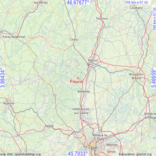
Fleurie GPS coordinates[2]
46° 11' 31.884" North, 4° 41' 50.892" East
| Map corner | latitude | longitude |
|---|---|---|
| Upper-left | 46.67677°, | 3.99434° |
| Center: | 46.19219°, | 4.69747° |
| Lower-right: | 45.7033°, | 5.40059° |
| Map W x H: | 108.2×108.2 km | = 67.2×67.2mi |
| max Lat: | 51.07786° ⇑63.7% North |
| Fleurie: | 46.19219° |
| min Lat: | ⇓36.3% South 41.3874° |
| min Long | Fleurie | max Long |
| -5.08615° | 4.69747° | 9.52242° |
| W 73.7%⇐ | ⇒26.3% E |
Elevation
Elevation of Fleurie is 298 m = 978 ft, and this is 104.3 m = 342 ft above average elevation for this country.
| Max E: |
2333 m = 7654 ft | 19.3% |
| Fleurie | 298 m 978 ft | |
| Avg. | 193.7 m = 635 ft | |
Min E: |
-1 m = -3 ft | 80.7% |
See also: France elevation on elevation.city.
Geographical zone
Fleurie is located in North temperate zone (between Tropic of Cancer and the Arctic Circle). Distance of this North polar circle is 2265.1 km =1407.5 mi to North.| Distance of | km | miles | from Fleurie |
|---|---|---|---|
| North Pole | 4871 | 3026.7 | to North |
| Arctic Circle | 2265.1 | 1407.5 | to North |
| Tropic Cancer | 2530.2 | 1572.2 | to South |
| Equator | 5136.1 | 3191.4 | to South |


Nearby cities:
15 places around Fleurie: (largest is in red/bold)
• Cercié
8.3 km =5.2 mi,  194°
194°
• Chaintré
9 km =5.6 mi,  32°
32°
• Chânes
8 km =5 mi, 34°
• Corcelles-en-Beaujolais
4.7 km =2.9 mi,  154°
154°
• Crêches-sur-Saône
9 km =5.6 mi,  49°
49°
• Dracé
6.5 km =4 mi,  126°
126°
• Durette
7.1 km =4.4 mi,  206°
206°
• Juliénas
4.9 km =3 mi,  12°
12°
• La Chapelle-de-Guinchay
5.3 km =3.3 mi,  70°
70°
• Lancié
2.7 km =1.7 mi, 151°
• Lantignié
7.6 km =4.7 mi,  228°
228°
• Leynes
8.9 km =5.5 mi,  15°
15°
• Romanèche-Thorins
3.6 km =2.2 mi,  104°
104°
• Thoissey
8.4 km =5.2 mi,  105°
105°
• Villié-Morgon
3.6 km =2.2 mi,  201°
201°
Sources, notices
• [Note1] Compared only with cities in France existing in our database
• [Src1] Map data: © OpenStreetMap contributors (CC-BY-SA)
• [Src2] Other city data from geonames.org with taken over terms of usage.
• [Src3] Geographical zone / Annual Mean Temperature by Robert A. Rohde @ Wikipedia
