Romanèche-Thorins geodata
Romanèche-Thorins (Bourgogne-Franche-Comté) is a populated place; located in France in Europe/Paris (GMT+2) time zone. With population of 1,743 people, there are 5432 cities with bigger population in this country. Compared to other cities in France, 63.8% of cities are located further ↑North; 74.2% of cities are located further ←West and 64% of cities have lower elevation than Romanèche-Thorins. Note1
Administrative division(s):
- Level 1: Bourgogne-Franche-Comté
- Level 2: Département de Saône-et-Loire
- Level 3: Arrondissement de Mâcon
- Level 4: Romanèche-Thorins


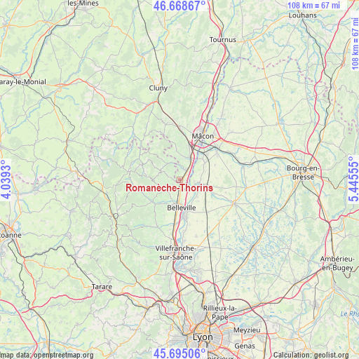
Romanèche-Thorins GPS coordinates[2]
46° 11' 2.472" North, 4° 44' 32.712" East
| Map corner | latitude | longitude |
|---|---|---|
| Upper-left | 46.66867°, | 4.0393° |
| Center: | 46.18402°, | 4.74242° |
| Lower-right: | 45.69506°, | 5.44555° |
| Map W x H: | 108.3×108.3 km | = 67.3×67.3mi |
| max Lat: | 51.07786° ⇑63.8% North |
| Romanèche-Thorins: | 46.18402° |
| min Lat: | ⇓36.2% South 41.3874° |
| min Long | Romanèche-Thor | max Long |
| -5.08615° | 4.74242° | 9.52242° |
| W 74.2%⇐ | ⇒25.8% E |
Elevation
Elevation of Romanèche-Thorins is 189 m = 620 ft, and this is 4.7 m = 15 ft below average elevation for this country.
| Max E: |
2333 m = 7654 ft | 36% |
| Avg. | 193.7 m = 635 ft | |
| Romanèche-Thorins | 189 m = 620 ft | |
Min E: |
-1 m = -3 ft | 64% |
See also: France elevation on elevation.city.
Geographical zone
Romanèche-Thorins is located in North temperate zone (between Tropic of Cancer and the Arctic Circle). Distance of this North polar circle is 2266 km =1408 mi to North.| Distance of | km | miles | from Romanèche-Thorins |
|---|---|---|---|
| North Pole | 4871.9 | 3027.3 | to North |
| Arctic Circle | 2266 | 1408 | to North |
| Tropic Cancer | 2529.3 | 1571.6 | to South |
| Equator | 5135.2 | 3190.9 | to South |


Nearby cities:
15 places around Romanèche-Thorins: (largest is in red/bold)
• Belleville
8.4 km =5.2 mi,  176°
176°
• Chânes
7.6 km =4.7 mi,  8°
8°
• Corcelles-en-Beaujolais
3.6 km =2.2 mi,  203°
203°
• Crêches-sur-Saône
7.6 km =4.7 mi,  26°
26°
• Dracé
3.5 km =2.2 mi,  149°
149°
• Fleurie
3.6 km =2.2 mi,  284°
284°
• Garnerans
8.1 km =5 mi,  70°
70°
• Juliénas
6.2 km =3.9 mi,  337°
337°
• La Chapelle-de-Guinchay
3.1 km =1.9 mi, 29°
• Lancié
2.6 km =1.6 mi,  236°
236°
• Mogneneins
7.3 km =4.5 mi,  133°
133°
• Saint-Didier-sur-Chalaronne
5.7 km =3.5 mi,  97°
97°
• Taponas
7.2 km =4.5 mi,  164°
164°
• Thoissey
4.8 km =3 mi,  105°
105°
• Villié-Morgon
5.3 km =3.3 mi, 243°
Sources, notices
• [Note1] Compared only with cities in France existing in our database
• [Src1] Map data: © OpenStreetMap contributors (CC-BY-SA)
• [Src2] Other city data from geonames.org with taken over terms of usage.
• [Src3] Geographical zone / Annual Mean Temperature by Robert A. Rohde @ Wikipedia
