Verneuil-en-Halatte geodata
Verneuil-en-Halatte (Hauts-de-France) is a populated place; located in France in Europe/Paris (GMT+2) time zone. With population of 4,254 people, there are 2313 cities with bigger population in this country. Compared to other cities in France, 85.7% of cities are located further ↓South; 51% of cities are located further ←West and 86.7% of cities have higher elevation than Verneuil-en-Halatte. Note1
Administrative division(s):
- Level 1: Hauts-de-France
- Level 2: Département de l'Oise
- Level 3: Arrondissement de Senlis
- Level 4: Verneuil-en-Halatte


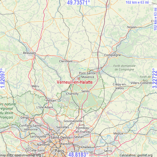
Verneuil-en-Halatte GPS coordinates[2]
49° 16' 44.904" North, 2° 31' 26.76" East
| Map corner | latitude | longitude |
|---|---|---|
| Upper-left | 49.73571°, | 1.82097° |
| Center: | 49.27914°, | 2.5241° |
| Lower-right: | 48.8183°, | 3.22722° |
| Map W x H: | 102×102 km | = 63.4×63.4mi |
| max Lat: | 51.07786° ⇑14.3% North |
| Verneuil-en-Halatte: | 49.27914° |
| min Lat: | ⇓85.7% South 41.3874° |
| min Long | Verneuil-en-Hal | max Long |
| -5.08615° | 2.5241° | 9.52242° |
| W 51%⇐ | ⇒49% E |
Elevation
Elevation of Verneuil-en-Halatte is 38 m = 125 ft, and this is 155.7 m = 511 ft below average elevation for this country.
| Max E: |
2333 m = 7654 ft | 86.7% |
| Avg. | 193.7 m = 635 ft | |
| Verneuil-en-Halatte | 38 m = 125 ft | |
Min E: |
-1 m = -3 ft | 13.3% |
See also: France elevation on elevation.city.
Geographical zone
Verneuil-en-Halatte is located in North temperate zone (between Tropic of Cancer and the Arctic Circle). Distance of this North polar circle is 1921.8 km =1194.2 mi to North.| Distance of | km | miles | from Verneuil-en-Halatte |
|---|---|---|---|
| North Pole | 4527.7 | 2813.4 | to North |
| Arctic Circle | 1921.8 | 1194.2 | to North |
| Tropic Cancer | 2873.4 | 1785.4 | to South |
| Equator | 5479.3 | 3404.7 | to South |


Nearby cities:
15 places around Verneuil-en-Halatte: (largest is in red/bold)
• Angicourt
3.9 km =2.4 mi,  338°
338°
• Apremont
6.3 km =3.9 mi,  190°
190°
• Aumont-en-Halatte
5.4 km =3.4 mi,  159°
159°
• Brenouille
3.3 km =2.1 mi,  26°
26°
• Cinqueux
4.3 km =2.7 mi,  5°
5°
• Creil
3.8 km =2.4 mi,  228°
228°
• Fleurines
4.9 km =3 mi,  117°
117°
• Laigneville
5.8 km =3.6 mi,  283°
283°
• Mogneville
5.5 km =3.4 mi,  316°
316°
• Monceaux
4.8 km =3 mi,  24°
24°
• Monchy-Saint-Éloi
4.3 km =2.7 mi,  286°
286°
• Nogent-sur-Oise
4 km =2.5 mi,  257°
257°
• Rieux
2.4 km =1.5 mi,  346°
346°
• Verderonne
5.9 km =3.7 mi, 341°
• Villers-Saint-Paul
2.7 km =1.7 mi, 293°
Sources, notices
• [Note1] Compared only with cities in France existing in our database
• [Src1] Map data: © OpenStreetMap contributors (CC-BY-SA)
• [Src2] Other city data from geonames.org with taken over terms of usage.
• [Src3] Geographical zone / Annual Mean Temperature by Robert A. Rohde @ Wikipedia
