Creil geodata
Creil (Hauts-de-France) is a populated place; located in France in Europe/Paris (GMT+2) time zone. With population of 31,863 people, there are 249 cities with bigger population in this country. Compared to other cities in France, 85.3% of cities are located further ↓South; 50.3% of cities are located further ←West and 72.3% of cities have higher elevation than Creil. Note1
Administrative division(s):
- Level 1: Hauts-de-France
- Level 2: Département de l'Oise
- Level 3: Arrondissement de Senlis
- Level 4: Creil


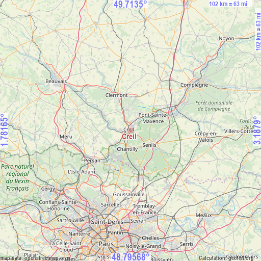
Creil GPS coordinates[2]
49° 15' 24.192" North, 2° 29' 5.172" East
| Map corner | latitude | longitude |
|---|---|---|
| Upper-left | 49.7135°, | 1.78165° |
| Center: | 49.25672°, | 2.48477° |
| Lower-right: | 48.79568°, | 3.1879° |
| Map W x H: | 102.1×102.1 km | = 63.4×63.4mi |
| max Lat: | 51.07786° ⇑14.7% North |
| Creil: | 49.25672° |
| min Lat: | ⇓85.3% South 41.3874° |
| min Long | Creil | max Long |
| -5.08615° | 2.48477° | 9.52242° |
| W 50.3%⇐ | ⇒49.7% E |
Elevation
Elevation of Creil is 73 m = 240 ft, and this is 120.7 m = 396 ft below average elevation for this country.
| Max E: |
2333 m = 7654 ft | 72.3% |
| Avg. | 193.7 m = 635 ft | |
| Creil | 73 m = 240 ft | |
Min E: |
-1 m = -3 ft | 27.7% |
See also: France elevation on elevation.city.
Geographical zone
Creil is located in North temperate zone (between Tropic of Cancer and the Arctic Circle). Distance of this North polar circle is 1924.3 km =1195.7 mi to North.| Distance of | km | miles | from Creil |
|---|---|---|---|
| North Pole | 4530.2 | 2814.9 | to North |
| Arctic Circle | 1924.3 | 1195.7 | to North |
| Tropic Cancer | 2870.9 | 1783.9 | to South |
| Equator | 5476.8 | 3403.1 | to South |


Nearby cities:
15 places around Creil: (largest is in red/bold)
• Angicourt
6.3 km =3.9 mi,  12°
12°
• Apremont
4 km =2.5 mi,  155°
155°
• Aumont-en-Halatte
5.4 km =3.4 mi,  118°
118°
• Cramoisy
6 km =3.7 mi,  268°
268°
• Laigneville
4.8 km =3 mi,  323°
323°
• Mogneville
6.6 km =4.1 mi,  351°
351°
• Monchy-Saint-Éloi
4 km =2.5 mi,  341°
341°
• Montataire
3.4 km =2.1 mi, 274°
• Nogent-sur-Oise
1.9 km =1.2 mi,  328°
328°
• Rieux
5.3 km =3.3 mi,  25°
25°
• Saint-Maximin
4.5 km =2.8 mi,  210°
210°
• Thiverny
3.6 km =2.2 mi,  261°
261°
• Verneuil-en-Halatte
3.8 km =2.4 mi,  48°
48°
• Villers-Saint-Paul
3.6 km =2.2 mi, 5°
• Vineuil-Saint-Firmin
6.3 km =3.9 mi,  172°
172°
Sources, notices
• [Note1] Compared only with cities in France existing in our database
• [Src1] Map data: © OpenStreetMap contributors (CC-BY-SA)
• [Src2] Other city data from geonames.org with taken over terms of usage.
• [Src3] Geographical zone / Annual Mean Temperature by Robert A. Rohde @ Wikipedia
