Villerest geodata
Villerest (Auvergne-Rhône-Alpes) is a populated place; located in France in Europe/Paris (GMT+2) time zone. With population of 4,397 people, there are 2244 cities with bigger population in this country. Compared to other cities in France, 66.3% of cities are located further ↑North; 68.2% of cities are located further ←West and 80.3% of cities have lower elevation than Villerest. Note1
Administrative division(s):
- Level 1: Auvergne-Rhône-Alpes
- Level 2: Département de la Loire
- Level 3: Arrondissement de Roanne
- Level 4: Villerest


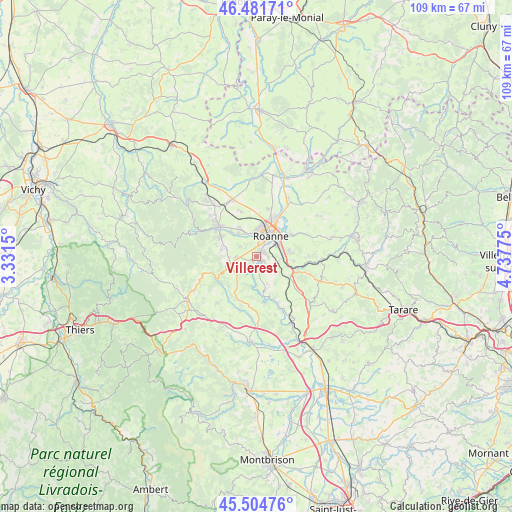
Villerest GPS coordinates[2]
45° 59' 43.404" North, 4° 2' 4.668" East
| Map corner | latitude | longitude |
|---|---|---|
| Upper-left | 46.48171°, | 3.3315° |
| Center: | 45.99539°, | 4.03463° |
| Lower-right: | 45.50476°, | 4.73775° |
| Map W x H: | 108.6×108.6 km | = 67.5×67.5mi |
| max Lat: | 51.07786° ⇑66.3% North |
| Villerest: | 45.99539° |
| min Lat: | ⇓33.7% South 41.3874° |
| min Long | Villerest | max Long |
| -5.08615° | 4.03463° | 9.52242° |
| W 68.2%⇐ | ⇒31.8% E |
Elevation
Elevation of Villerest is 293 m = 961 ft, and this is 99.3 m = 326 ft above average elevation for this country.
| Max E: |
2333 m = 7654 ft | 19.7% |
| Villerest | 293 m 961 ft | |
| Avg. | 193.7 m = 635 ft | |
Min E: |
-1 m = -3 ft | 80.3% |
See also: France elevation on elevation.city.
Geographical zone
Villerest is located in North temperate zone (between Tropic of Cancer and the Arctic Circle). Distance of this North polar circle is 2287 km =1421.1 mi to North.| Distance of | km | miles | from Villerest |
|---|---|---|---|
| North Pole | 4892.9 | 3040.3 | to North |
| Arctic Circle | 2287 | 1421.1 | to North |
| Tropic Cancer | 2508.3 | 1558.6 | to South |
| Equator | 5114.2 | 3177.8 | to South |


Nearby cities:
15 places around Villerest: (largest is in red/bold)
• Commelle
1.9 km =1.2 mi,  71°
71°
• Cordelle
6.1 km =3.8 mi,  160°
160°
• Le Coteau
5.2 km =3.2 mi,  59°
59°
• Lentigny
4.3 km =2.7 mi,  267°
267°
• Notre-Dame-de-Boisset
7.7 km =4.8 mi,  85°
85°
• Ouches
4.2 km =2.6 mi,  302°
302°
• Parigny
5.2 km =3.2 mi, 94°
• Pouilly-les-Nonains
6.8 km =4.2 mi,  323°
323°
• Riorges
5.4 km =3.4 mi,  6°
6°
• Roanne
5.2 km =3.2 mi,  29°
29°
• Saint-Alban-les-Eaux
7 km =4.3 mi,  284°
284°
• Saint-Cyr-de-Favières
5.3 km =3.3 mi,  126°
126°
• Saint-Léger-sur-Roanne
5.9 km =3.7 mi,  330°
330°
• Saint-Vincent-de-Boisset
6.9 km =4.3 mi,  78°
78°
• Villemontais
6.3 km =3.9 mi,  255°
255°
Sources, notices
• [Note1] Compared only with cities in France existing in our database
• [Src1] Map data: © OpenStreetMap contributors (CC-BY-SA)
• [Src2] Other city data from geonames.org with taken over terms of usage.
• [Src3] Geographical zone / Annual Mean Temperature by Robert A. Rohde @ Wikipedia
