Roanne geodata
Roanne (Auvergne-Rhône-Alpes) is a seat of a third-order administrative division; located in France in Europe/Paris (GMT+2) time zone. With population of 39,840 people, there are 182 cities with bigger population in this country. Compared to other cities in France, 65.8% of cities are located further ↑North; 68.5% of cities are located further ←West and 77.8% of cities have lower elevation than Roanne. Note1
Administrative division(s):
- Level 1: Auvergne-Rhône-Alpes
- Level 2: Département de la Loire
- Level 3: Arrondissement de Roanne
- Level 4: Roanne


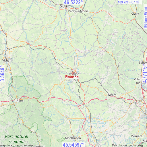
Roanne GPS coordinates[2]
46° 2' 10.464" North, 4° 4' 4.872" East
| Map corner | latitude | longitude |
|---|---|---|
| Upper-left | 46.5222°, | 3.3649° |
| Center: | 46.03624°, | 4.06802° |
| Lower-right: | 45.54597°, | 4.77115° |
| Map W x H: | 108.5×108.5 km | = 67.4×67.4mi |
| max Lat: | 51.07786° ⇑65.8% North |
| Roanne: | 46.03624° |
| min Lat: | ⇓34.2% South 41.3874° |
| min Long | Roanne | max Long |
| -5.08615° | 4.06802° | 9.52242° |
| W 68.5%⇐ | ⇒31.5% E |
Elevation
Elevation of Roanne is 270 m = 886 ft, and this is 76.3 m = 250 ft above average elevation for this country.
| Max E: |
2333 m = 7654 ft | 22.2% |
| Roanne | 270 m 886 ft | |
| Avg. | 193.7 m = 635 ft | |
Min E: |
-1 m = -3 ft | 77.8% |
See also: France elevation on elevation.city.
Geographical zone
Roanne is located in North temperate zone (between Tropic of Cancer and the Arctic Circle). Distance of this North polar circle is 2282.4 km =1418.2 mi to North.| Distance of | km | miles | from Roanne |
|---|---|---|---|
| North Pole | 4888.3 | 3037.4 | to North |
| Arctic Circle | 2282.4 | 1418.2 | to North |
| Tropic Cancer | 2512.8 | 1561.4 | to South |
| Equator | 5118.8 | 3180.7 | to South |


Nearby cities:
15 places around Roanne: (largest is in red/bold)
• Commelle
4 km =2.5 mi,  191°
191°
• Le Coteau
2.7 km =1.7 mi,  135°
135°
• Lentigny
8.3 km =5.2 mi,  235°
235°
• Mably
3.2 km =2 mi,  349°
349°
• Notre-Dame-de-Boisset
6.4 km =4 mi,  127°
127°
• Ouches
6.6 km =4.1 mi,  249°
249°
• Parigny
5.6 km =3.5 mi,  152°
152°
• Perreux
4.5 km =2.8 mi,  84°
84°
• Pouilly-les-Nonains
6.7 km =4.2 mi,  278°
278°
• Riorges
2.1 km =1.3 mi,  293°
293°
• Saint-Cyr-de-Favières
7.9 km =4.9 mi,  167°
167°
• Saint-Léger-sur-Roanne
5.6 km =3.5 mi, 276°
• Saint-Romain-la-Motte
7.8 km =4.8 mi,  310°
310°
• Saint-Vincent-de-Boisset
5.3 km =3.3 mi, 127°
• Villerest
5.2 km =3.2 mi,  209°
209°
Sources, notices
• [Note1] Compared only with cities in France existing in our database
• [Src1] Map data: © OpenStreetMap contributors (CC-BY-SA)
• [Src2] Other city data from geonames.org with taken over terms of usage.
• [Src3] Geographical zone / Annual Mean Temperature by Robert A. Rohde @ Wikipedia
