Riorges geodata
Riorges (Auvergne-Rhône-Alpes) is a populated place; located in France in Europe/Paris (GMT+2) time zone. With population of 10,763 people, there are 889 cities with bigger population in this country. Compared to other cities in France, 65.8% of cities are located further ↑North; 68.3% of cities are located further ←West and 79.2% of cities have lower elevation than Riorges. Note1
Administrative division(s):
- Level 1: Auvergne-Rhône-Alpes
- Level 2: Département de la Loire
- Level 3: Arrondissement de Roanne
- Level 4: Riorges


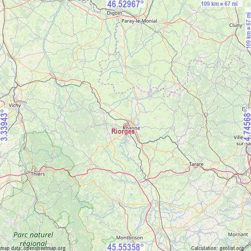
Riorges GPS coordinates[2]
46° 2' 37.608" North, 4° 2' 33.18" East
| Map corner | latitude | longitude |
|---|---|---|
| Upper-left | 46.52967°, | 3.33943° |
| Center: | 46.04378°, | 4.04255° |
| Lower-right: | 45.55358°, | 4.74568° |
| Map W x H: | 108.5×108.5 km | = 67.4×67.4mi |
| max Lat: | 51.07786° ⇑65.8% North |
| Riorges: | 46.04378° |
| min Lat: | ⇓34.2% South 41.3874° |
| min Long | Riorges | max Long |
| -5.08615° | 4.04255° | 9.52242° |
| W 68.3%⇐ | ⇒31.7% E |
Elevation
Elevation of Riorges is 282 m = 925 ft, and this is 88.3 m = 290 ft above average elevation for this country.
| Max E: |
2333 m = 7654 ft | 20.8% |
| Riorges | 282 m 925 ft | |
| Avg. | 193.7 m = 635 ft | |
Min E: |
-1 m = -3 ft | 79.2% |
See also: France elevation on elevation.city.
Geographical zone
Riorges is located in North temperate zone (between Tropic of Cancer and the Arctic Circle). Distance of this North polar circle is 2281.6 km =1417.7 mi to North.| Distance of | km | miles | from Riorges |
|---|---|---|---|
| North Pole | 4887.5 | 3037 | to North |
| Arctic Circle | 2281.6 | 1417.7 | to North |
| Tropic Cancer | 2513.7 | 1561.9 | to South |
| Equator | 5119.6 | 3181.2 | to South |


Nearby cities:
15 places around Riorges: (largest is in red/bold)
• Commelle
4.9 km =3 mi,  166°
166°
• Le Coteau
4.7 km =2.9 mi,  125°
125°
• Lentigny
7.4 km =4.6 mi,  221°
221°
• Mably
2.7 km =1.7 mi,  30°
30°
• Notre-Dame-de-Boisset
8.5 km =5.3 mi,  124°
124°
• Ouches
5.2 km =3.2 mi,  233°
233°
• Parigny
7.4 km =4.6 mi,  141°
141°
• Perreux
6.5 km =4 mi,  93°
93°
• Pouilly-les-Nonains
4.6 km =2.9 mi,  271°
271°
• Roanne
2.1 km =1.3 mi,  113°
113°
• Saint-Alban-les-Eaux
8.2 km =5.1 mi,  244°
244°
• Saint-Léger-sur-Roanne
3.6 km =2.2 mi, 266°
• Saint-Romain-la-Motte
5.8 km =3.6 mi,  316°
316°
• Saint-Vincent-de-Boisset
7.4 km =4.6 mi, 123°
• Villerest
5.4 km =3.4 mi,  186°
186°
Sources, notices
• [Note1] Compared only with cities in France existing in our database
• [Src1] Map data: © OpenStreetMap contributors (CC-BY-SA)
• [Src2] Other city data from geonames.org with taken over terms of usage.
• [Src3] Geographical zone / Annual Mean Temperature by Robert A. Rohde @ Wikipedia
