Villeneuve-le-Comte geodata
Villeneuve-le-Comte (Île-de-France) is a populated place; located in France in Europe/Paris (GMT+2) time zone. With population of 1,764 people, there are 5367 cities with bigger population in this country. Compared to other cities in France, 75.8% of cities are located further ↓South; 55.4% of cities are located further ←West and 51.7% of cities have higher elevation than Villeneuve-le-Comte. Note1
Administrative division(s):
- Level 1: Île-de-France
- Level 2: Seine-et-Marne
- Level 3: Arrondissement de Provins
- Level 4: Villeneuve-le-Comte


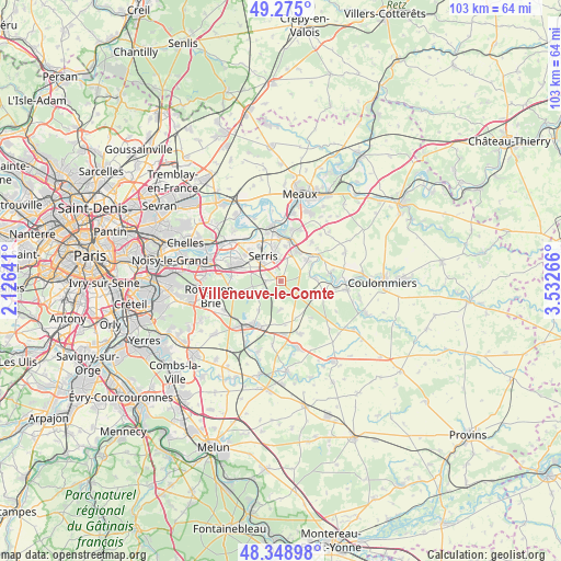
Villeneuve-le-Comte GPS coordinates[2]
48° 48' 50.868" North, 2° 49' 46.308" East
| Map corner | latitude | longitude |
|---|---|---|
| Upper-left | 49.275°, | 2.12641° |
| Center: | 48.81413°, | 2.82953° |
| Lower-right: | 48.34898°, | 3.53266° |
| Map W x H: | 103×103 km | = 64×64mi |
| max Lat: | 51.07786° ⇑24.2% North |
| Villeneuve-le-Comte: | 48.81413° |
| min Lat: | ⇓75.8% South 41.3874° |
| min Long | Villeneuve-le-C | max Long |
| -5.08615° | 2.82953° | 9.52242° |
| W 55.4%⇐ | ⇒44.6% E |
Elevation
Elevation of Villeneuve-le-Comte is 126 m = 413 ft, and this is 67.7 m = 222 ft below average elevation for this country.
| Max E: |
2333 m = 7654 ft | 51.7% |
| Avg. | 193.7 m = 635 ft | |
| Villeneuve-le-Comte | 126 m = 413 ft | |
Min E: |
-1 m = -3 ft | 48.3% |
See also: France elevation on elevation.city.
Geographical zone
Villeneuve-le-Comte is located in North temperate zone (between Tropic of Cancer and the Arctic Circle). Distance of this North polar circle is 1973.6 km =1226.3 mi to North.| Distance of | km | miles | from Villeneuve-le-Comte |
|---|---|---|---|
| North Pole | 4579.4 | 2845.5 | to North |
| Arctic Circle | 1973.6 | 1226.3 | to North |
| Tropic Cancer | 2821.7 | 1753.3 | to South |
| Equator | 5427.6 | 3372.6 | to South |


Nearby cities:
15 places around Villeneuve-le-Comte: (largest is in red/bold)
• Bailly-Romainvilliers
3.7 km =2.3 mi,  353°
353°
• Coutevroult
5.6 km =3.5 mi,  17°
17°
• Dammartin-sur-Tigeaux
6.6 km =4.1 mi,  84°
84°
• Favières
6.9 km =4.3 mi,  215°
215°
• Jossigny
6.1 km =3.8 mi,  295°
295°
• La Houssaye-en-Brie
7.2 km =4.5 mi,  158°
158°
• Magny-le-Hongre
5.6 km =3.5 mi, 349°
• Montry
7.8 km =4.8 mi,  359°
359°
• Mortcerf
7 km =4.3 mi,  113°
113°
• Neufmoutiers-en-Brie
5 km =3.1 mi,  178°
178°
• Saint-Germain-sur-Morin
7.8 km =4.8 mi,  11°
11°
• Serris
4.7 km =2.9 mi,  317°
317°
• Villeneuve-Saint-Denis
2.6 km =1.6 mi,  273°
273°
• Villiers-sur-Morin
6.3 km =3.9 mi,  34°
34°
• Voulangis
6.4 km =4 mi,  48°
48°
Sources, notices
• [Note1] Compared only with cities in France existing in our database
• [Src1] Map data: © OpenStreetMap contributors (CC-BY-SA)
• [Src2] Other city data from geonames.org with taken over terms of usage.
• [Src3] Geographical zone / Annual Mean Temperature by Robert A. Rohde @ Wikipedia
