Villeneuve-la-Comptal geodata
Villeneuve-la-Comptal (Occitanie) is a populated place; located in France in Europe/Paris (GMT+2) time zone. With population of 1,122 people, there are 7997 cities with bigger population in this country. Compared to other cities in France, 95.9% of cities are located further ↑North; 58.1% of cities are located further →East and 68.1% of cities have lower elevation than Villeneuve-la-Comptal. Note1
Administrative division(s):
- Level 1: Occitanie
- Level 2: Département de l'Aude
- Level 3: Arrondissement de Carcassonne
- Level 4: Villeneuve-la-Comptal


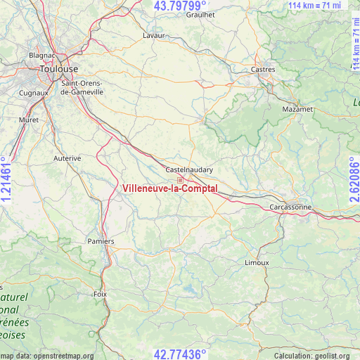
Villeneuve-la-Comptal GPS coordinates[2]
43° 17' 17.988" North, 1° 55' 3.828" East
| Map corner | latitude | longitude |
|---|---|---|
| Upper-left | 43.79799°, | 1.21461° |
| Center: | 43.28833°, | 1.91773° |
| Lower-right: | 42.77436°, | 2.62086° |
| Map W x H: | 113.8×113.8 km | = 70.7×70.7mi |
| max Lat: | 51.07786° ⇑95.9% North |
| Villeneuve-la-Comptal: | 43.28833° |
| min Lat: | ⇓4.1% South 41.3874° |
| min Long | Villeneuve-la-C | max Long |
| -5.08615° | 1.91773° | 9.52242° |
| W 41.9%⇐ | ⇒58.1% E |
Elevation
Elevation of Villeneuve-la-Comptal is 210 m = 689 ft, and this is 16.3 m = 53 ft above average elevation for this country.
| Max E: |
2333 m = 7654 ft | 31.9% |
| Villeneuve-la-Comptal | 210 m 689 ft | |
| Avg. | 193.7 m = 635 ft | |
Min E: |
-1 m = -3 ft | 68.1% |
See also: France elevation on elevation.city.
Geographical zone
Villeneuve-la-Comptal is located in North temperate zone (between Tropic of Cancer and the Arctic Circle). Distance of this Northern Tropic circle is 2207.3 km =1371.6 mi to South.| Distance of | km | miles | from Villeneuve-la-Comptal |
|---|---|---|---|
| North Pole | 5193.9 | 3227.3 | to North |
| Arctic Circle | 2588 | 1608.1 | to North |
| Tropic Cancer | 2207.3 | 1371.6 | to South |
| Equator | 4813.2 | 2990.8 | to South |


Nearby cities:
15 places around Villeneuve-la-Comptal: (largest is in red/bold)
• Avignonet-Lauragais
12.9 km =8 mi,  312°
312°
• Belpech
16.7 km =10.4 mi,  233°
233°
• Bram
16.6 km =10.3 mi,  107°
107°
• Castelnaudary
4.5 km =2.8 mi,  41°
41°
• Fanjeaux
14.7 km =9.1 mi,  140°
140°
• Labastide-d’Anjou
8.4 km =5.2 mi,  320°
320°
• Lasbordes
10.3 km =6.4 mi,  85°
85°
• Mas-Saintes-Puelles
4.2 km =2.6 mi, 310°
• Pexiora
9.9 km =6.2 mi,  103°
103°
• Saint-Félix-Lauragais
18 km =11.2 mi,  352°
352°
• Saint-Martin-Lalande
8.4 km =5.2 mi,  81°
81°
• Saint-Papoul
10.7 km =6.6 mi,  63°
63°
• Salles-sur-l’Hers
10.7 km =6.6 mi,  272°
272°
• Villasavary
12.5 km =7.8 mi,  127°
127°
• Villepinte
13.8 km =8.6 mi, 92°
Sources, notices
• [Note1] Compared only with cities in France existing in our database
• [Src1] Map data: © OpenStreetMap contributors (CC-BY-SA)
• [Src2] Other city data from geonames.org with taken over terms of usage.
• [Src3] Geographical zone / Annual Mean Temperature by Robert A. Rohde @ Wikipedia
