Salles-sur-l’Hers geodata
Salles-sur-l’Hers (Occitanie) is a populated place; located in France in Europe/Paris (GMT+2) time zone. With population of 594 people, there are 13430 cities with bigger population in this country. Compared to other cities in France, 95.8% of cities are located further ↑North; 59.5% of cities are located further →East and 74% of cities have lower elevation than Salles-sur-l’Hers. Note1
Administrative division(s):
- Level 1: Occitanie
- Level 2: Département de l'Aude
- Level 3: Arrondissement de Carcassonne
- Level 4: Salles-sur-l'Hers


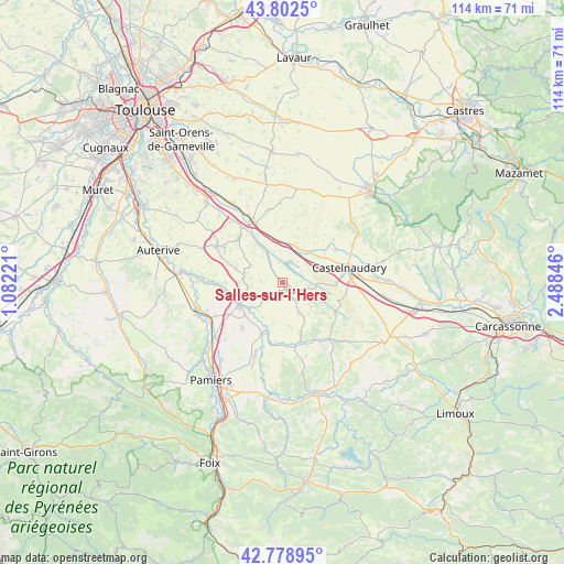
Salles-sur-l’Hers GPS coordinates[2]
43° 17' 34.368" North, 1° 47' 7.224" East
| Map corner | latitude | longitude |
|---|---|---|
| Upper-left | 43.8025°, | 1.08221° |
| Center: | 43.29288°, | 1.78534° |
| Lower-right: | 42.77895°, | 2.48846° |
| Map W x H: | 113.8×113.8 km | = 70.7×70.7mi |
| max Lat: | 51.07786° ⇑95.8% North |
| Salles-sur-l’Hers: | 43.29288° |
| min Lat: | ⇓4.2% South 41.3874° |
| min Long | Salles-sur-l’ | max Long |
| -5.08615° | 1.78534° | 9.52242° |
| W 40.5%⇐ | ⇒59.5% E |
Elevation
Elevation of Salles-sur-l’Hers is 242 m = 794 ft, and this is 48.3 m = 158 ft above average elevation for this country.
| Max E: |
2333 m = 7654 ft | 26% |
| Salles-sur-l’Hers | 242 m 794 ft | |
| Avg. | 193.7 m = 635 ft | |
Min E: |
-1 m = -3 ft | 74% |
See also: France elevation on elevation.city.
Geographical zone
Salles-sur-l’Hers is located in North temperate zone (between Tropic of Cancer and the Arctic Circle). Distance of this Northern Tropic circle is 2207.8 km =1371.9 mi to South.| Distance of | km | miles | from Salles-sur-l’Hers |
|---|---|---|---|
| North Pole | 5193.3 | 3227 | to North |
| Arctic Circle | 2587.5 | 1607.8 | to North |
| Tropic Cancer | 2207.8 | 1371.9 | to South |
| Equator | 4813.7 | 2991.1 | to South |


Nearby cities:
15 places around Salles-sur-l’Hers: (largest is in red/bold)
• Avignonet-Lauragais
8.3 km =5.2 mi,  8°
8°
• Belpech
10.7 km =6.6 mi,  194°
194°
• Calmont
12.6 km =7.8 mi,  267°
267°
• Castelnaudary
14 km =8.7 mi,  78°
78°
• Gardouch
13.7 km =8.5 mi,  322°
322°
• Labastide-d’Anjou
8 km =5 mi,  41°
41°
• Mas-Saintes-Puelles
7.8 km =4.8 mi,  73°
73°
• Mazères
9.9 km =6.2 mi,  241°
241°
• Montaut
16.4 km =10.2 mi,  221°
221°
• Montesquieu-Lauragais
18.7 km =11.6 mi, 317°
• Montgaillard-Lauragais
16.9 km =10.5 mi,  335°
335°
• Nailloux
15 km =9.3 mi,  298°
298°
• Saverdun
18.3 km =11.4 mi,  249°
249°
• Villefranche-de-Lauragais
13.1 km =8.1 mi, 335°
• Villeneuve-la-Comptal
10.7 km =6.6 mi,  92°
92°
Sources, notices
• [Note1] Compared only with cities in France existing in our database
• [Src1] Map data: © OpenStreetMap contributors (CC-BY-SA)
• [Src2] Other city data from geonames.org with taken over terms of usage.
• [Src3] Geographical zone / Annual Mean Temperature by Robert A. Rohde @ Wikipedia
