Villejust geodata
Villejust (Île-de-France) is a populated place; located in France in Europe/Paris (GMT+2) time zone. With population of 1,742 people, there are 5433 cities with bigger population in this country. Compared to other cities in France, 72.8% of cities are located further ↓South; 53.8% of cities are located further →East and 56.8% of cities have lower elevation than Villejust. Note1
Administrative division(s):
- Level 1: Île-de-France
- Level 2: Département de l'Essonne
- Level 3: Arrondissement de Palaiseau
- Level 4: Villejust


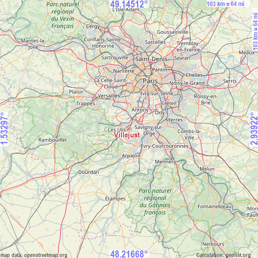
Villejust GPS coordinates[2]
48° 40' 58.944" North, 2° 14' 9.96" East
| Map corner | latitude | longitude |
|---|---|---|
| Upper-left | 49.14512°, | 1.53297° |
| Center: | 48.68304°, | 2.2361° |
| Lower-right: | 48.21668°, | 2.93922° |
| Map W x H: | 103.2×103.2 km | = 64.1×64.1mi |
| max Lat: | 51.07786° ⇑27.2% North |
| Villejust: | 48.68304° |
| min Lat: | ⇓72.8% South 41.3874° |
| min Long | Villejust | max Long |
| -5.08615° | 2.2361° | 9.52242° |
| W 46.2%⇐ | ⇒53.8% E |
Elevation
Elevation of Villejust is 157 m = 515 ft, and this is 36.7 m = 120 ft below average elevation for this country.
| Max E: |
2333 m = 7654 ft | 43.2% |
| Avg. | 193.7 m = 635 ft | |
| Villejust | 157 m = 515 ft | |
Min E: |
-1 m = -3 ft | 56.8% |
See also: France elevation on elevation.city.
Geographical zone
Villejust is located in North temperate zone (between Tropic of Cancer and the Arctic Circle). Distance of this North polar circle is 1988.1 km =1235.3 mi to North.| Distance of | km | miles | from Villejust |
|---|---|---|---|
| North Pole | 4594 | 2854.6 | to North |
| Arctic Circle | 1988.1 | 1235.3 | to North |
| Tropic Cancer | 2807.1 | 1744.3 | to South |
| Equator | 5413 | 3363.5 | to South |


Nearby cities:
15 places around Villejust: (largest is in red/bold)
• Ballainvilliers
4.8 km =3 mi,  100°
100°
• Bures-sur-Yvette
5.2 km =3.2 mi,  291°
291°
• Champlan
4.3 km =2.7 mi,  48°
48°
• La Ville-du-Bois
3.9 km =2.4 mi,  142°
142°
• Les Ulis
4.9 km =3 mi,  268°
268°
• Longjumeau
5.4 km =3.4 mi,  75°
75°
• Marcoussis
4.8 km =3 mi,  177°
177°
• Montlhéry
5.6 km =3.5 mi,  149°
149°
• Nozay
2.7 km =1.7 mi,  171°
171°
• Orsay
3.9 km =2.4 mi, 291°
• Palaiseau
4 km =2.5 mi,  14°
14°
• Saulx-les-Chartreux
2.4 km =1.5 mi,  69°
69°
• Villebon-sur-Yvette
2.6 km =1.6 mi, 6°
• Villiers-sur-Orge
5.4 km =3.4 mi,  119°
119°
• Épinay-sur-Orge
5.6 km =3.5 mi, 101°
Sources, notices
• [Note1] Compared only with cities in France existing in our database
• [Src1] Map data: © OpenStreetMap contributors (CC-BY-SA)
• [Src2] Other city data from geonames.org with taken over terms of usage.
• [Src3] Geographical zone / Annual Mean Temperature by Robert A. Rohde @ Wikipedia
