Orsay geodata
Orsay (Île-de-France) is a populated place; located in France in Europe/Paris (GMT+2) time zone. With population of 17,817 people, there are 530 cities with bigger population in this country. Compared to other cities in France, 73.1% of cities are located further ↓South; 54.7% of cities are located further →East and 65.6% of cities have higher elevation than Orsay. Note1
Administrative division(s):
- Level 1: Île-de-France
- Level 2: Département de l'Essonne
- Level 3: Arrondissement de Palaiseau
- Level 4: Orsay


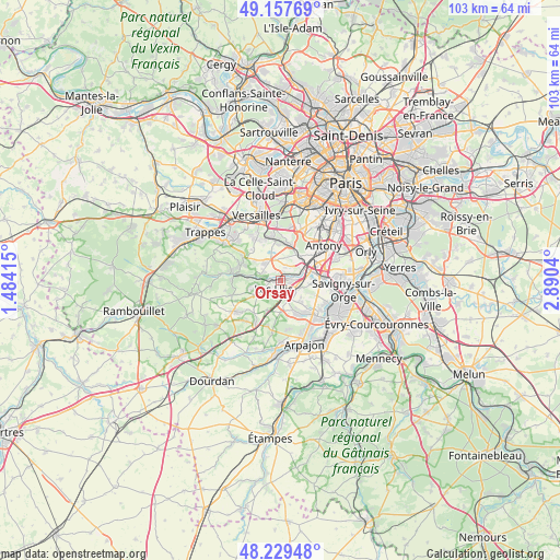
Orsay GPS coordinates[2]
48° 41' 44.592" North, 2° 11' 14.172" East
| Map corner | latitude | longitude |
|---|---|---|
| Upper-left | 49.15769°, | 1.48415° |
| Center: | 48.69572°, | 2.18727° |
| Lower-right: | 48.22948°, | 2.8904° |
| Map W x H: | 103.2×103.2 km | = 64.1×64.1mi |
| max Lat: | 51.07786° ⇑26.9% North |
| Orsay: | 48.69572° |
| min Lat: | ⇓73.1% South 41.3874° |
| min Long | Orsay | max Long |
| -5.08615° | 2.18727° | 9.52242° |
| W 45.3%⇐ | ⇒54.7% E |
Elevation
Elevation of Orsay is 88 m = 289 ft, and this is 105.7 m = 347 ft below average elevation for this country.
| Max E: |
2333 m = 7654 ft | 65.6% |
| Avg. | 193.7 m = 635 ft | |
| Orsay | 88 m = 289 ft | |
Min E: |
-1 m = -3 ft | 34.4% |
See also: France elevation on elevation.city.
Geographical zone
Orsay is located in North temperate zone (between Tropic of Cancer and the Arctic Circle). Distance of this North polar circle is 1986.7 km =1234.5 mi to North.| Distance of | km | miles | from Orsay |
|---|---|---|---|
| North Pole | 4592.6 | 2853.7 | to North |
| Arctic Circle | 1986.7 | 1234.5 | to North |
| Tropic Cancer | 2808.5 | 1745.1 | to South |
| Equator | 5414.5 | 3364.4 | to South |


Nearby cities:
15 places around Orsay: (largest is in red/bold)
• Bures-sur-Yvette
1.3 km =0.8 mi,  290°
290°
• Gif-sur-Yvette
4.2 km =2.6 mi,  250°
250°
• Gometz-la-Ville
5 km =3.1 mi,  238°
238°
• Gometz-le-Châtel
4.1 km =2.5 mi, 241°
• Igny
6.1 km =3.8 mi,  26°
26°
• Janvry
5.8 km =3.6 mi,  205°
205°
• Les Ulis
2 km =1.2 mi,  219°
219°
• Nozay
5.7 km =3.5 mi,  135°
135°
• Palaiseau
5.2 km =3.2 mi,  61°
61°
• Saclay
4.3 km =2.7 mi,  342°
342°
• Saint-Aubin
3.9 km =2.4 mi,  300°
300°
• Saulx-les-Chartreux
5.9 km =3.7 mi,  95°
95°
• Vauhallan
4.4 km =2.7 mi,  15°
15°
• Villebon-sur-Yvette
4 km =2.5 mi,  73°
73°
• Villejust
3.9 km =2.4 mi,  111°
111°
Sources, notices
• [Note1] Compared only with cities in France existing in our database
• [Src1] Map data: © OpenStreetMap contributors (CC-BY-SA)
• [Src2] Other city data from geonames.org with taken over terms of usage.
• [Src3] Geographical zone / Annual Mean Temperature by Robert A. Rohde @ Wikipedia
