Bures-sur-Yvette geodata
Bures-sur-Yvette (Île-de-France) is a populated place; located in France in Europe/Paris (GMT+1) time zone. With population of 10,411 people, there are 912 cities with bigger population in this country. Compared to other cities in France, 73.2% of cities are located further ↓South; 54.8% of cities are located further →East and 77% of cities have higher elevation than Bures-sur-Yvette. Note1
Administrative division(s):
- Level 1: Île-de-France
- Level 2: Département de l'Essonne
- Level 3: Arrondissement de Palaiseau
- Level 4: Bures-sur-Yvette


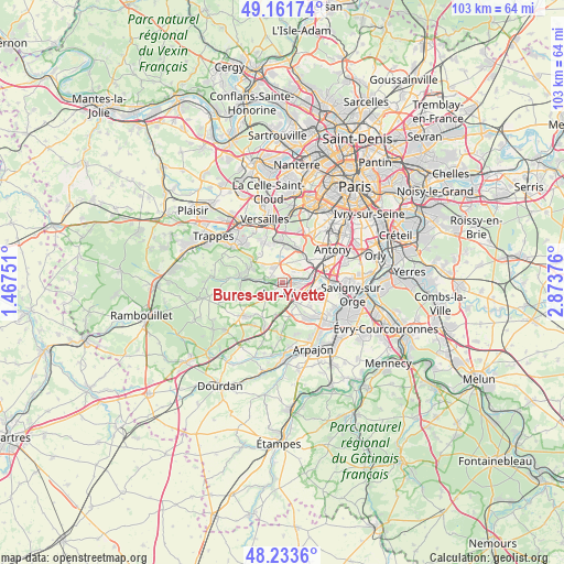
Bures-sur-Yvette GPS coordinates[2]
48° 41' 59.316" North, 2° 10' 14.304" East
| Map corner | latitude | longitude |
|---|---|---|
| Upper-left | 49.16174°, | 1.46751° |
| Center: | 48.69981°, | 2.17064° |
| Lower-right: | 48.2336°, | 2.87376° |
| Map W x H: | 103.2×103.2 km | = 64.1×64.1mi |
| max Lat: | 51.07786° ⇑26.8% North |
| Bures-sur-Yvette: | 48.69981° |
| min Lat: | ⇓73.2% South 41.3874° |
| min Long | Bures-sur-Yvett | max Long |
| -5.08615° | 2.17064° | 9.52242° |
| W 45.2%⇐ | ⇒54.8% E |
Elevation
Elevation of Bures-sur-Yvette is 62 m = 203 ft, and this is 131.7 m = 432 ft below average elevation for this country.
| Max E: |
2333 m = 7654 ft | 77% |
| Avg. | 193.7 m = 635 ft | |
| Bures-sur-Yvette | 62 m = 203 ft | |
Min E: |
-1 m = -3 ft | 23% |
See also: France elevation on elevation.city.
Geographical zone
Bures-sur-Yvette is located in North temperate zone (between Tropic of Cancer and the Arctic Circle). Distance of this North polar circle is 1986.3 km =1234.2 mi to North.| Distance of | km | miles | from Bures-sur-Yvette |
|---|---|---|---|
| North Pole | 4592.2 | 2853.5 | to North |
| Arctic Circle | 1986.3 | 1234.2 | to North |
| Tropic Cancer | 2809 | 1745.4 | to South |
| Equator | 5414.9 | 3364.7 | to South |


Nearby cities:
15 places around Bures-sur-Yvette: (largest is in red/bold)
• Gif-sur-Yvette
3.3 km =2.1 mi,  236°
236°
• Gometz-la-Ville
4.3 km =2.7 mi,  225°
225°
• Gometz-le-Châtel
3.4 km =2.1 mi, 225°
• Igny
6.3 km =3.9 mi,  38°
38°
• Janvry
5.9 km =3.7 mi,  192°
192°
• Jouy-en-Josas
6.6 km =4.1 mi,  359°
359°
• Les Ulis
2 km =1.2 mi,  182°
182°
• Orsay
1.3 km =0.8 mi,  110°
110°
• Palaiseau
6.2 km =3.9 mi,  70°
70°
• Saclay
3.6 km =2.2 mi, 358°
• Saint-Aubin
2.6 km =1.6 mi,  304°
304°
• Vauhallan
4.4 km =2.7 mi,  32°
32°
• Villebon-sur-Yvette
5.1 km =3.2 mi,  82°
82°
• Villejust
5.2 km =3.2 mi, 111°
• Villiers-le-Bâcle
4.9 km =3 mi,  309°
309°
Sources, notices
• [Note1] Compared only with cities in France existing in our database
• [Src1] Map data: © OpenStreetMap contributors (CC-BY-SA)
• [Src2] Other city data from geonames.org with taken over terms of usage.
• [Src3] Geographical zone / Annual Mean Temperature by Robert A. Rohde @ Wikipedia
