Palaiseau geodata
Palaiseau (Île-de-France) is a seat of a third-order administrative division; located in France in Europe/Paris (GMT+2) time zone. With population of 31,987 people, there are 247 cities with bigger population in this country. Compared to other cities in France, 73.7% of cities are located further ↓South; 53.5% of cities are located further →East and 63.6% of cities have higher elevation than Palaiseau. Note1
Administrative division(s):
- Level 1: Île-de-France
- Level 2: Département de l'Essonne
- Level 3: Arrondissement de Palaiseau
- Level 4: Palaiseau


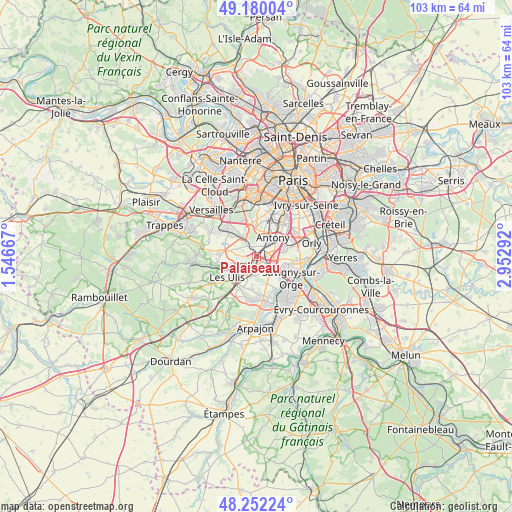
Palaiseau GPS coordinates[2]
48° 43' 5.808" North, 2° 14' 59.28" East
| Map corner | latitude | longitude |
|---|---|---|
| Upper-left | 49.18004°, | 1.54667° |
| Center: | 48.71828°, | 2.2498° |
| Lower-right: | 48.25224°, | 2.95292° |
| Map W x H: | 103.2×103.2 km | = 64.1×64.1mi |
| max Lat: | 51.07786° ⇑26.3% North |
| Palaiseau: | 48.71828° |
| min Lat: | ⇓73.7% South 41.3874° |
| min Long | Palaiseau | max Long |
| -5.08615° | 2.2498° | 9.52242° |
| W 46.5%⇐ | ⇒53.5% E |
Elevation
Elevation of Palaiseau is 93 m = 305 ft, and this is 100.7 m = 330 ft below average elevation for this country.
| Max E: |
2333 m = 7654 ft | 63.6% |
| Avg. | 193.7 m = 635 ft | |
| Palaiseau | 93 m = 305 ft | |
Min E: |
-1 m = -3 ft | 36.4% |
See also: France elevation on elevation.city.
Geographical zone
Palaiseau is located in North temperate zone (between Tropic of Cancer and the Arctic Circle). Distance of this North polar circle is 1984.2 km =1232.9 mi to North.| Distance of | km | miles | from Palaiseau |
|---|---|---|---|
| North Pole | 4590.1 | 2852.2 | to North |
| Arctic Circle | 1984.2 | 1232.9 | to North |
| Tropic Cancer | 2811 | 1746.7 | to South |
| Equator | 5417 | 3366 | to South |


Nearby cities:
15 places around Palaiseau: (largest is in red/bold)
• Antony
5.2 km =3.2 mi,  41°
41°
• Bièvres
4.9 km =3 mi,  332°
332°
• Champlan
2.5 km =1.6 mi,  116°
116°
• Chilly-Mazarin
4.9 km =3 mi,  94°
94°
• Châtenay-Malabry
5.3 km =3.3 mi,  13°
13°
• Igny
3.5 km =2.2 mi, 327°
• Longjumeau
5 km =3.1 mi, 121°
• Massy
2.6 km =1.6 mi,  68°
68°
• Orsay
5.2 km =3.2 mi,  241°
241°
• Saulx-les-Chartreux
3.3 km =2.1 mi,  157°
157°
• Vauhallan
3.8 km =2.4 mi,  296°
296°
• Verrières-le-Buisson
3.3 km =2.1 mi,  23°
23°
• Villebon-sur-Yvette
1.5 km =0.9 mi,  207°
207°
• Villejust
4 km =2.5 mi,  194°
194°
• Wissous
5.7 km =3.5 mi, 72°
Sources, notices
• [Note1] Compared only with cities in France existing in our database
• [Src1] Map data: © OpenStreetMap contributors (CC-BY-SA)
• [Src2] Other city data from geonames.org with taken over terms of usage.
• [Src3] Geographical zone / Annual Mean Temperature by Robert A. Rohde @ Wikipedia
