Villeblevin geodata
Villeblevin (Bourgogne-Franche-Comté) is a populated place; located in France in Europe/Paris (GMT+2) time zone. With population of 1,636 people, there are 5709 cities with bigger population in this country. Compared to other cities in France, 65% of cities are located further ↓South; 59% of cities are located further ←West and 70.1% of cities have higher elevation than Villeblevin. Note1
Administrative division(s):
- Level 1: Bourgogne-Franche-Comté
- Level 2: Département de l'Yonne
- Level 3: Arrondissement de Sens
- Level 4: Villeblevin


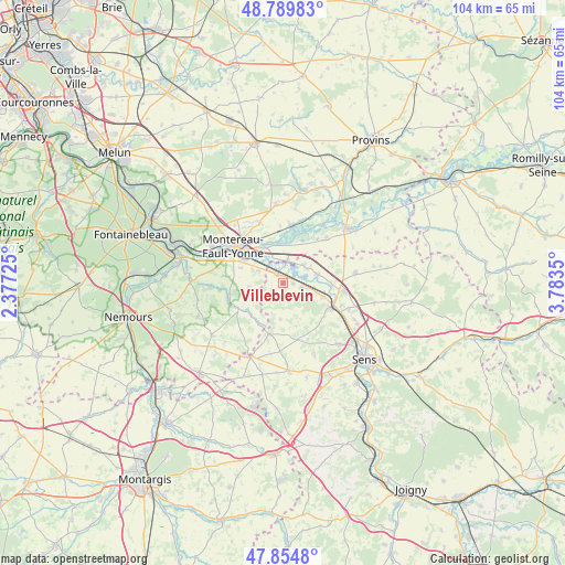
Villeblevin GPS coordinates[2]
48° 19' 28.056" North, 3° 4' 49.368" East
| Map corner | latitude | longitude |
|---|---|---|
| Upper-left | 48.78983°, | 2.37725° |
| Center: | 48.32446°, | 3.08038° |
| Lower-right: | 47.8548°, | 3.7835° |
| Map W x H: | 104×104 km | = 64.6×64.6mi |
| max Lat: | 51.07786° ⇑35% North |
| Villeblevin: | 48.32446° |
| min Lat: | ⇓65% South 41.3874° |
| min Long | Villeblevin | max Long |
| -5.08615° | 3.08038° | 9.52242° |
| W 59%⇐ | ⇒41% E |
Elevation
Elevation of Villeblevin is 78 m = 256 ft, and this is 115.7 m = 380 ft below average elevation for this country.
| Max E: |
2333 m = 7654 ft | 70.1% |
| Avg. | 193.7 m = 635 ft | |
| Villeblevin | 78 m = 256 ft | |
Min E: |
-1 m = -3 ft | 29.9% |
See also: France elevation on elevation.city.
Geographical zone
Villeblevin is located in North temperate zone (between Tropic of Cancer and the Arctic Circle). Distance of this North polar circle is 2028 km =1260.1 mi to North.| Distance of | km | miles | from Villeblevin |
|---|---|---|---|
| North Pole | 4633.9 | 2879.4 | to North |
| Arctic Circle | 2028 | 1260.1 | to North |
| Tropic Cancer | 2767.3 | 1719.5 | to South |
| Equator | 5373.2 | 3338.8 | to South |


Nearby cities:
15 places around Villeblevin: (largest is in red/bold)
• Blennes
8.6 km =5.3 mi,  209°
209°
• Cannes-Écluse
8.1 km =5 mi,  301°
301°
• Champigny
4 km =2.5 mi,  102°
102°
• Chaumont
1.9 km =1.2 mi, 98°
• Courlon-sur-Yonne
6.6 km =4.1 mi,  75°
75°
• Esmans
8.1 km =5 mi,  287°
287°
• La Brosse-Montceaux
5.1 km =3.2 mi, 296°
• Marolles-sur-Seine
7.7 km =4.8 mi,  334°
334°
• Misy-sur-Yonne
4.1 km =2.5 mi,  9°
9°
• Pont-sur-Yonne
10.1 km =6.3 mi,  117°
117°
• Villemanoche
7.9 km =4.9 mi,  110°
110°
• Villeneuve-la-Guyard
2.3 km =1.4 mi,  323°
323°
• Villethierry
6.8 km =4.2 mi,  183°
183°
• Vinneuf
5.1 km =3.2 mi,  59°
59°
• Voulx
9.6 km =6 mi,  240°
240°
Sources, notices
• [Note1] Compared only with cities in France existing in our database
• [Src1] Map data: © OpenStreetMap contributors (CC-BY-SA)
• [Src2] Other city data from geonames.org with taken over terms of usage.
• [Src3] Geographical zone / Annual Mean Temperature by Robert A. Rohde @ Wikipedia
