Marolles-sur-Seine geodata
Marolles-sur-Seine (Île-de-France) is a populated place; located in France in Europe/Paris (GMT+2) time zone. With population of 1,521 people, there are 6113 cities with bigger population in this country. Compared to other cities in France, 66.1% of cities are located further ↓South; 58.3% of cities are located further ←West and 80.6% of cities have higher elevation than Marolles-sur-Seine. Note1
Administrative division(s):
- Level 1: Île-de-France
- Level 2: Seine-et-Marne
- Level 3: Arrondissement de Provins
- Level 4: Marolles-sur-Seine


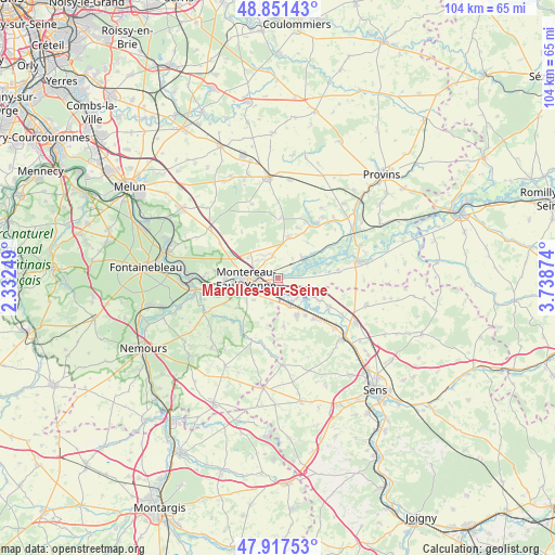
Marolles-sur-Seine GPS coordinates[2]
48° 23' 11.832" North, 3° 2' 8.232" East
| Map corner | latitude | longitude |
|---|---|---|
| Upper-left | 48.85143°, | 2.33249° |
| Center: | 48.38662°, | 3.03562° |
| Lower-right: | 47.91753°, | 3.73874° |
| Map W x H: | 103.8×103.8 km | = 64.5×64.5mi |
| max Lat: | 51.07786° ⇑33.9% North |
| Marolles-sur-Seine: | 48.38662° |
| min Lat: | ⇓66.1% South 41.3874° |
| min Long | Marolles-sur-Se | max Long |
| -5.08615° | 3.03562° | 9.52242° |
| W 58.3%⇐ | ⇒41.7% E |
Elevation
Elevation of Marolles-sur-Seine is 53 m = 174 ft, and this is 140.7 m = 462 ft below average elevation for this country.
| Max E: |
2333 m = 7654 ft | 80.6% |
| Avg. | 193.7 m = 635 ft | |
| Marolles-sur-Seine | 53 m = 174 ft | |
Min E: |
-1 m = -3 ft | 19.4% |
See also: France elevation on elevation.city.
Geographical zone
Marolles-sur-Seine is located in North temperate zone (between Tropic of Cancer and the Arctic Circle). Distance of this North polar circle is 2021.1 km =1255.9 mi to North.| Distance of | km | miles | from Marolles-sur-Seine |
|---|---|---|---|
| North Pole | 4627 | 2875.1 | to North |
| Arctic Circle | 2021.1 | 1255.9 | to North |
| Tropic Cancer | 2774.2 | 1723.8 | to South |
| Equator | 5380.1 | 3343 | to South |


Nearby cities:
15 places around Marolles-sur-Seine: (largest is in red/bold)
• Cannes-Écluse
4.4 km =2.7 mi,  233°
233°
• Chaumont
8.9 km =5.5 mi,  144°
144°
• Châtenay-sur-Seine
5.6 km =3.5 mi,  51°
51°
• Esmans
6.3 km =3.9 mi,  224°
224°
• La Brosse-Montceaux
4.8 km =3 mi,  194°
194°
• Misy-sur-Yonne
4.9 km =3 mi,  125°
125°
• Montereau-Fault-Yonne
6.3 km =3.9 mi,  266°
266°
• Montigny-Lencoup
7.5 km =4.7 mi,  16°
16°
• Noisy-Rudignon
9.6 km =6 mi, 233°
• Saint-Germain-Laval
3.1 km =1.9 mi,  297°
297°
• Salins
4 km =2.5 mi,  344°
344°
• Varennes-sur-Seine
8.3 km =5.2 mi,  259°
259°
• Villeblevin
7.7 km =4.8 mi,  154°
154°
• Villeneuve-la-Guyard
5.4 km =3.4 mi,  159°
159°
• Vinneuf
8.8 km =5.5 mi,  119°
119°
Sources, notices
• [Note1] Compared only with cities in France existing in our database
• [Src1] Map data: © OpenStreetMap contributors (CC-BY-SA)
• [Src2] Other city data from geonames.org with taken over terms of usage.
• [Src3] Geographical zone / Annual Mean Temperature by Robert A. Rohde @ Wikipedia
