Misy-sur-Yonne geodata
Misy-sur-Yonne (Île-de-France) is a populated place; located in France in Europe/Paris (GMT+2) time zone. With population of 815 people, there are 10429 cities with bigger population in this country. Compared to other cities in France, 65.7% of cities are located further ↓South; 59.1% of cities are located further ←West and 77% of cities have higher elevation than Misy-sur-Yonne. Note1
Administrative division(s):
- Level 1: Île-de-France
- Level 2: Seine-et-Marne
- Level 3: Arrondissement de Provins
- Level 4: Misy-sur-Yonne


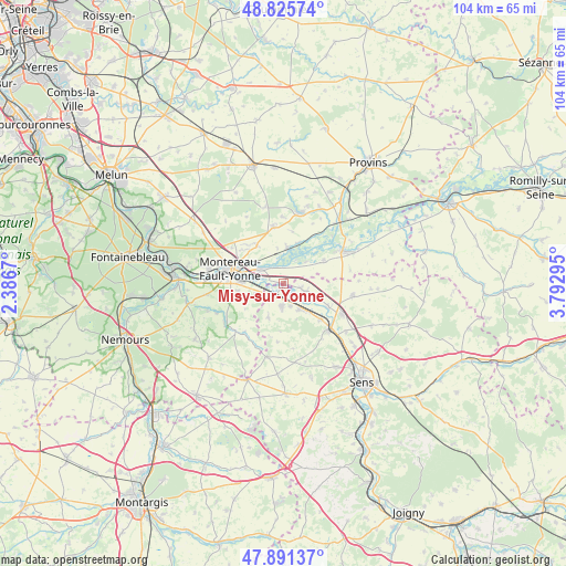
Misy-sur-Yonne GPS coordinates[2]
48° 21' 38.52" North, 3° 5' 23.352" East
| Map corner | latitude | longitude |
|---|---|---|
| Upper-left | 48.82574°, | 2.3867° |
| Center: | 48.3607°, | 3.08982° |
| Lower-right: | 47.89137°, | 3.79295° |
| Map W x H: | 103.9×103.9 km | = 64.6×64.6mi |
| max Lat: | 51.07786° ⇑34.3% North |
| Misy-sur-Yonne: | 48.3607° |
| min Lat: | ⇓65.7% South 41.3874° |
| min Long | Misy-sur-Yonne | max Long |
| -5.08615° | 3.08982° | 9.52242° |
| W 59.1%⇐ | ⇒40.9% E |
Elevation
Elevation of Misy-sur-Yonne is 62 m = 203 ft, and this is 131.7 m = 432 ft below average elevation for this country.
| Max E: |
2333 m = 7654 ft | 77% |
| Avg. | 193.7 m = 635 ft | |
| Misy-sur-Yonne | 62 m = 203 ft | |
Min E: |
-1 m = -3 ft | 23% |
See also: France elevation on elevation.city.
Geographical zone
Misy-sur-Yonne is located in North temperate zone (between Tropic of Cancer and the Arctic Circle). Distance of this North polar circle is 2024 km =1257.7 mi to North.| Distance of | km | miles | from Misy-sur-Yonne |
|---|---|---|---|
| North Pole | 4629.9 | 2876.9 | to North |
| Arctic Circle | 2024 | 1257.7 | to North |
| Tropic Cancer | 2771.3 | 1722 | to South |
| Equator | 5377.2 | 3341.2 | to South |


Nearby cities:
15 places around Misy-sur-Yonne: (largest is in red/bold)
• Bazoches-lès-Bray
8.4 km =5.2 mi,  59°
59°
• Cannes-Écluse
7.6 km =4.7 mi,  271°
271°
• Champigny
5.9 km =3.7 mi,  146°
146°
• Chaumont
4.5 km =2.8 mi,  164°
164°
• Châtenay-sur-Seine
6.4 km =4 mi,  3°
3°
• Courlon-sur-Yonne
6.2 km =3.9 mi,  112°
112°
• Esmans
8.6 km =5.3 mi,  258°
258°
• La Brosse-Montceaux
5.5 km =3.4 mi,  251°
251°
• Marolles-sur-Seine
4.9 km =3 mi,  305°
305°
• Saint-Germain-Laval
8.1 km =5 mi,  302°
302°
• Salins
8.4 km =5.2 mi,  323°
323°
• Villeblevin
4.1 km =2.5 mi,  189°
189°
• Villemanoche
9.5 km =5.9 mi,  135°
135°
• Villeneuve-la-Guyard
3 km =1.9 mi,  223°
223°
• Vinneuf
4 km =2.5 mi, 110°
Sources, notices
• [Note1] Compared only with cities in France existing in our database
• [Src1] Map data: © OpenStreetMap contributors (CC-BY-SA)
• [Src2] Other city data from geonames.org with taken over terms of usage.
• [Src3] Geographical zone / Annual Mean Temperature by Robert A. Rohde @ Wikipedia
