Villebernier geodata
Villebernier (Pays de la Loire) is a populated place; located in France in Europe/Paris (GMT+2) time zone. With population of 1,407 people, there are 6578 cities with bigger population in this country. Compared to other cities in France, 52.3% of cities are located further ↑North; 78.3% of cities are located further →East and 89.9% of cities have higher elevation than Villebernier. Note1
Administrative division(s):
- Level 1: Pays de la Loire
- Level 2: Département de Maine-et-Loire
- Level 3: Arrondissement de Saumur
- Level 4: Villebernier


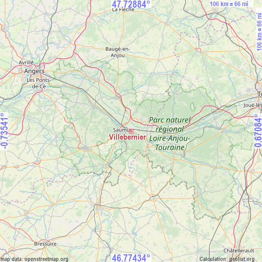
Villebernier GPS coordinates[2]
47° 15' 13.464" North, 0° 1' 56.244" West
| Map corner | latitude | longitude |
|---|---|---|
| Upper-left | 47.72884°, | -0.73541° |
| Center: | 47.25374°, | -0.03229° |
| Lower-right: | 46.77434°, | 0.67084° |
| Map W x H: | 106.1×106.1 km | = 65.9×65.9mi |
| max Lat: | 51.07786° ⇑52.3% North |
| Villebernier: | 47.25374° |
| min Lat: | ⇓47.7% South 41.3874° |
| min Long | Villebernier | max Long |
| -5.08615° | -0.03229° | 9.52242° |
| W 21.7%⇐ | ⇒78.3% E |
Elevation
Elevation of Villebernier is 30 m = 98 ft, and this is 163.7 m = 537 ft below average elevation for this country.
| Max E: |
2333 m = 7654 ft | 89.9% |
| Avg. | 193.7 m = 635 ft | |
| Villebernier | 30 m = 98 ft | |
Min E: |
-1 m = -3 ft | 10.1% |
See also: France elevation on elevation.city.
Geographical zone
Villebernier is located in North temperate zone (between Tropic of Cancer and the Arctic Circle). Distance of this North polar circle is 2147.1 km =1334.1 mi to North.| Distance of | km | miles | from Villebernier |
|---|---|---|---|
| North Pole | 4752.9 | 2953.3 | to North |
| Arctic Circle | 2147.1 | 1334.1 | to North |
| Tropic Cancer | 2648.2 | 1645.5 | to South |
| Equator | 5254.1 | 3264.7 | to South |


Nearby cities:
15 places around Villebernier: (largest is in red/bold)
• Allonnes
6.2 km =3.9 mi,  44°
44°
• Brain-sur-Allonnes
9.2 km =5.7 mi,  53°
53°
• Brézé
9.2 km =5.7 mi,  193°
193°
• Chacé
5.3 km =3.3 mi,  214°
214°
• Distré
6.8 km =4.2 mi,  239°
239°
• Le Coudray-Macouard
9 km =5.6 mi,  224°
224°
• Montsoreau
8.3 km =5.2 mi,  120°
120°
• Neuillé
9.8 km =6.1 mi,  358°
358°
• Rou-Marson
9.5 km =5.9 mi,  257°
257°
• Saint-Cyr-en-Bourg
6.9 km =4.3 mi,  198°
198°
• Saumur
3.5 km =2.2 mi,  279°
279°
• Souzay-Champigny
2.6 km =1.6 mi,  137°
137°
• Varennes-sur-Loire
6.7 km =4.2 mi,  105°
105°
• Varrains
4 km =2.5 mi, 211°
• Vivy
8.3 km =5.2 mi,  347°
347°
Sources, notices
• [Note1] Compared only with cities in France existing in our database
• [Src1] Map data: © OpenStreetMap contributors (CC-BY-SA)
• [Src2] Other city data from geonames.org with taken over terms of usage.
• [Src3] Geographical zone / Annual Mean Temperature by Robert A. Rohde @ Wikipedia
