Souzay-Champigny geodata
Souzay-Champigny (Pays de la Loire) is a populated place; located in France in Europe/Paris (GMT+2) time zone. With population of 718 people, there are 11561 cities with bigger population in this country. Compared to other cities in France, 52.5% of cities are located further ↑North; 78.2% of cities are located further →East and 86.7% of cities have higher elevation than Souzay-Champigny. Note1
Administrative division(s):
- Level 1: Pays de la Loire
- Level 2: Département de Maine-et-Loire
- Level 3: Arrondissement de Saumur
- Level 4: Souzay-Champigny


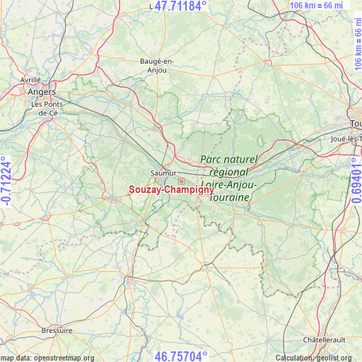
Souzay-Champigny GPS coordinates[2]
47° 14' 11.724" North, 0° 0' 32.832" West
| Map corner | latitude | longitude |
|---|---|---|
| Upper-left | 47.71184°, | -0.71224° |
| Center: | 47.23659°, | -0.00912° |
| Lower-right: | 46.75704°, | 0.69401° |
| Map W x H: | 106.2×106.2 km | = 66×66mi |
| max Lat: | 51.07786° ⇑52.5% North |
| Souzay-Champigny: | 47.23659° |
| min Lat: | ⇓47.5% South 41.3874° |
| min Long | Souzay-Champign | max Long |
| -5.08615° | -0.00912° | 9.52242° |
| W 21.8%⇐ | ⇒78.2% E |
Elevation
Elevation of Souzay-Champigny is 38 m = 125 ft, and this is 155.7 m = 511 ft below average elevation for this country.
| Max E: |
2333 m = 7654 ft | 86.7% |
| Avg. | 193.7 m = 635 ft | |
| Souzay-Champigny | 38 m = 125 ft | |
Min E: |
-1 m = -3 ft | 13.3% |
See also: France elevation on elevation.city.
Geographical zone
Souzay-Champigny is located in North temperate zone (between Tropic of Cancer and the Arctic Circle). Distance of this North polar circle is 2149 km =1335.3 mi to North.| Distance of | km | miles | from Souzay-Champigny |
|---|---|---|---|
| North Pole | 4754.8 | 2954.5 | to North |
| Arctic Circle | 2149 | 1335.3 | to North |
| Tropic Cancer | 2646.3 | 1644.3 | to South |
| Equator | 5252.2 | 3263.6 | to South |


Nearby cities:
15 places around Souzay-Champigny: (largest is in red/bold)
• Allonnes
6.8 km =4.2 mi,  21°
21°
• Brain-sur-Allonnes
9.3 km =5.8 mi,  37°
37°
• Brézé
8 km =5 mi,  209°
209°
• Chacé
5.3 km =3.3 mi,  242°
242°
• Chouzé-sur-Loire
10 km =6.2 mi,  89°
89°
• Distré
7.8 km =4.8 mi,  258°
258°
• Fontevraud-l'Abbaye
7.4 km =4.6 mi,  142°
142°
• Le Coudray-Macouard
9.3 km =5.8 mi, 241°
• Montsoreau
5.8 km =3.6 mi,  113°
113°
• Saint-Cyr-en-Bourg
6 km =3.7 mi,  220°
220°
• Saumur
5.8 km =3.6 mi,  295°
295°
• Varennes-sur-Loire
4.7 km =2.9 mi, 88°
• Varrains
4.1 km =2.5 mi,  248°
248°
• Villebernier
2.6 km =1.6 mi,  317°
317°
• Vivy
10.6 km =6.6 mi,  340°
340°
Sources, notices
• [Note1] Compared only with cities in France existing in our database
• [Src1] Map data: © OpenStreetMap contributors (CC-BY-SA)
• [Src2] Other city data from geonames.org with taken over terms of usage.
• [Src3] Geographical zone / Annual Mean Temperature by Robert A. Rohde @ Wikipedia
