Vivy geodata
Vivy (Pays de la Loire) is a populated place; located in France in Europe/Paris (GMT+2) time zone. With population of 2,054 people, there are 4675 cities with bigger population in this country. Compared to other cities in France, 51.1% of cities are located further ↑North; 78.5% of cities are located further →East and 89.9% of cities have higher elevation than Vivy. Note1
Administrative division(s):
- Level 1: Pays de la Loire
- Level 2: Département de Maine-et-Loire
- Level 3: Arrondissement de Saumur
- Level 4: Vivy


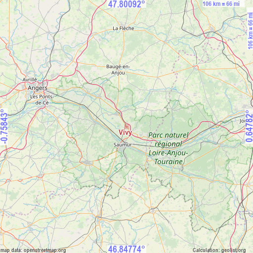
Vivy GPS coordinates[2]
47° 19' 35.328" North, 0° 3' 19.116" West
| Map corner | latitude | longitude |
|---|---|---|
| Upper-left | 47.80092°, | -0.75843° |
| Center: | 47.32648°, | -0.05531° |
| Lower-right: | 46.84774°, | 0.64782° |
| Map W x H: | 106×106 km | = 65.9×65.9mi |
| max Lat: | 51.07786° ⇑51.1% North |
| Vivy: | 47.32648° |
| min Lat: | ⇓48.9% South 41.3874° |
| min Long | Vivy | max Long |
| -5.08615° | -0.05531° | 9.52242° |
| W 21.5%⇐ | ⇒78.5% E |
Elevation
Elevation of Vivy is 30 m = 98 ft, and this is 163.7 m = 537 ft below average elevation for this country.
| Max E: |
2333 m = 7654 ft | 89.9% |
| Avg. | 193.7 m = 635 ft | |
| Vivy | 30 m = 98 ft | |
Min E: |
-1 m = -3 ft | 10.1% |
See also: France elevation on elevation.city.
Geographical zone
Vivy is located in North temperate zone (between Tropic of Cancer and the Arctic Circle). Distance of this North polar circle is 2139 km =1329.1 mi to North.| Distance of | km | miles | from Vivy |
|---|---|---|---|
| North Pole | 4744.9 | 2948.3 | to North |
| Arctic Circle | 2139 | 1329.1 | to North |
| Tropic Cancer | 2656.3 | 1650.5 | to South |
| Equator | 5262.2 | 3269.8 | to South |


Nearby cities:
15 places around Vivy: (largest is in red/bold)
• Allonnes
7.1 km =4.4 mi,  121°
121°
• Blou
4.1 km =2.5 mi,  18°
18°
• Brain-sur-Allonnes
9.4 km =5.8 mi,  105°
105°
• Chênehutte-Trèves-Cunault
8.1 km =5 mi,  257°
257°
• Distré
12.3 km =7.6 mi,  199°
199°
• Neuillé
2.2 km =1.4 mi,  41°
41°
• Saint-Clément-des-Levées
9.6 km =6 mi,  274°
274°
• Saint-Martin-de-la-Place
7.1 km =4.4 mi, 261°
• Saint-Philbert-du-Peuple
7.5 km =4.7 mi,  6°
6°
• Saumur
7.7 km =4.8 mi,  192°
192°
• Souzay-Champigny
10.6 km =6.6 mi,  160°
160°
• Varrains
11.5 km =7.1 mi,  181°
181°
• Vernantes
11 km =6.8 mi,  47°
47°
• Vernoil-le-Fourrier
12.2 km =7.6 mi,  58°
58°
• Villebernier
8.3 km =5.2 mi,  167°
167°
Sources, notices
• [Note1] Compared only with cities in France existing in our database
• [Src1] Map data: © OpenStreetMap contributors (CC-BY-SA)
• [Src2] Other city data from geonames.org with taken over terms of usage.
• [Src3] Geographical zone / Annual Mean Temperature by Robert A. Rohde @ Wikipedia
