Saumur geodata
Saumur (Pays de la Loire) is a seat of a third-order administrative division; located in France in Europe/Paris (GMT+2) time zone. With population of 33,229 people, there are 234 cities with bigger population in this country. Compared to other cities in France, 52.2% of cities are located further ↑North; 78.7% of cities are located further →East and 92% of cities have higher elevation than Saumur. Note1
Administrative division(s):
- Level 1: Pays de la Loire
- Level 2: Département de Maine-et-Loire
- Level 3: Arrondissement de Saumur
- Level 4: Saumur


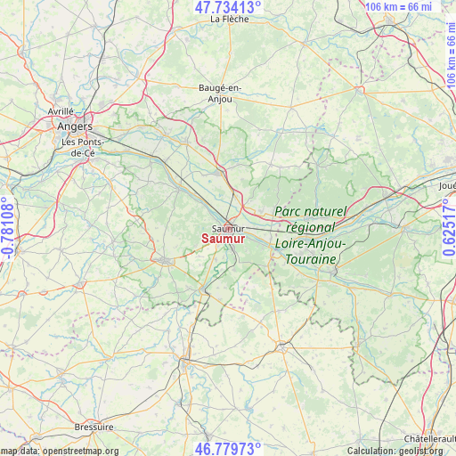
Saumur GPS coordinates[2]
47° 15' 32.688" North, 0° 4' 40.656" West
| Map corner | latitude | longitude |
|---|---|---|
| Upper-left | 47.73413°, | -0.78108° |
| Center: | 47.25908°, | -0.07796° |
| Lower-right: | 46.77973°, | 0.62517° |
| Map W x H: | 106.1×106.1 km | = 65.9×65.9mi |
| max Lat: | 51.07786° ⇑52.2% North |
| Saumur: | 47.25908° |
| min Lat: | ⇓47.8% South 41.3874° |
| min Long | Saumur | max Long |
| -5.08615° | -0.07796° | 9.52242° |
| W 21.3%⇐ | ⇒78.7% E |
Elevation
Elevation of Saumur is 25 m = 82 ft, and this is 168.7 m = 553 ft below average elevation for this country.
| Max E: |
2333 m = 7654 ft | 92% |
| Avg. | 193.7 m = 635 ft | |
| Saumur | 25 m = 82 ft | |
Min E: |
-1 m = -3 ft | 8% |
See also: France elevation on elevation.city.
Geographical zone
Saumur is located in North temperate zone (between Tropic of Cancer and the Arctic Circle). Distance of this North polar circle is 2146.5 km =1333.8 mi to North.| Distance of | km | miles | from Saumur |
|---|---|---|---|
| North Pole | 4752.3 | 2952.9 | to North |
| Arctic Circle | 2146.5 | 1333.8 | to North |
| Tropic Cancer | 2648.8 | 1645.9 | to South |
| Equator | 5254.7 | 3265.1 | to South |


Nearby cities:
15 places around Saumur: (largest is in red/bold)
• Allonnes
8.6 km =5.3 mi,  63°
63°
• Brézé
9.6 km =6 mi,  172°
172°
• Chacé
5 km =3.1 mi, 174°
• Chênehutte-Trèves-Cunault
8.5 km =5.3 mi,  312°
312°
• Distré
4.7 km =2.9 mi,  211°
211°
• Le Coudray-Macouard
7.6 km =4.7 mi,  202°
202°
• Les Ulmes
8.8 km =5.5 mi,  240°
240°
• Neuillé
9.7 km =6 mi,  19°
19°
• Rou-Marson
6.4 km =4 mi,  245°
245°
• Saint-Cyr-en-Bourg
7.2 km =4.5 mi, 169°
• Saint-Martin-de-la-Place
8.4 km =5.2 mi,  320°
320°
• Souzay-Champigny
5.8 km =3.6 mi,  115°
115°
• Varrains
4.2 km =2.6 mi,  161°
161°
• Villebernier
3.5 km =2.2 mi,  99°
99°
• Vivy
7.7 km =4.8 mi,  12°
12°
Sources, notices
• [Note1] Compared only with cities in France existing in our database
• [Src1] Map data: © OpenStreetMap contributors (CC-BY-SA)
• [Src2] Other city data from geonames.org with taken over terms of usage.
• [Src3] Geographical zone / Annual Mean Temperature by Robert A. Rohde @ Wikipedia
