Vielle-Saint-Girons geodata
Vielle-Saint-Girons (Nouvelle-Aquitaine) is a populated place; located in France in Europe/Paris (GMT+2) time zone. With population of 1,087 people, there are 8216 cities with bigger population in this country. Compared to other cities in France, 87.5% of cities are located further ↑North; 90.7% of cities are located further →East and 90.3% of cities have higher elevation than Vielle-Saint-Girons. Note1
Administrative division(s):
- Level 1: Nouvelle-Aquitaine
- Level 2: Landes
- Level 3: Arrondissement de Dax
- Level 4: Vielle-Saint-Girons


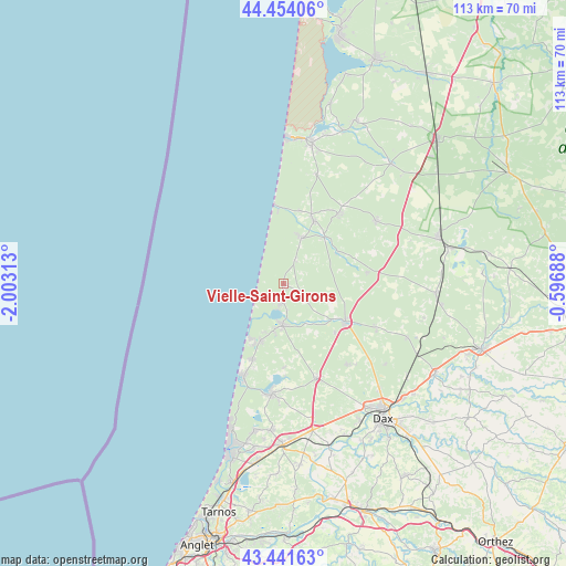
Vielle-Saint-Girons GPS coordinates[2]
43° 57' 0" North, 1° 18' 0" West
| Map corner | latitude | longitude |
|---|---|---|
| Upper-left | 44.45406°, | -2.00313° |
| Center: | 43.95°, | -1.3° |
| Lower-right: | 43.44163°, | -0.59688° |
| Map W x H: | 112.6×112.6 km | = 70×70mi |
| max Lat: | 51.07786° ⇑87.5% North |
| Vielle-Saint-Girons: | 43.95° |
| min Lat: | ⇓12.5% South 41.3874° |
| min Long | Vielle-Saint-Gi | max Long |
| -5.08615° | -1.3° | 9.52242° |
| W 9.3%⇐ | ⇒90.7% E |
Elevation
Elevation of Vielle-Saint-Girons is 29 m = 95 ft, and this is 164.7 m = 540 ft below average elevation for this country.
| Max E: |
2333 m = 7654 ft | 90.3% |
| Avg. | 193.7 m = 635 ft | |
| Vielle-Saint-Girons | 29 m = 95 ft | |
Min E: |
-1 m = -3 ft | 9.7% |
See also: France elevation on elevation.city.
Geographical zone
Vielle-Saint-Girons is located in North temperate zone (between Tropic of Cancer and the Arctic Circle). Distance of this Northern Tropic circle is 2280.9 km =1417.3 mi to South.| Distance of | km | miles | from Vielle-Saint-Girons |
|---|---|---|---|
| North Pole | 5120.3 | 3181.6 | to North |
| Arctic Circle | 2514.4 | 1562.4 | to North |
| Tropic Cancer | 2280.9 | 1417.3 | to South |
| Equator | 4886.8 | 3036.5 | to South |


Nearby cities:
15 places around Vielle-Saint-Girons: (largest is in red/bold)
• Bias
22.7 km =14.1 mi,  16°
16°
• Castets
14.5 km =9 mi,  121°
121°
• Herm
20.3 km =12.6 mi,  142°
142°
• Lesperon
16.7 km =10.4 mi,  82°
82°
• Linxe
5.5 km =3.4 mi,  127°
127°
• Lit-et-Mixe
10 km =6.2 mi, 22°
• Léon
8.1 km =5 mi,  180°
180°
• Magescq
19.8 km =12.3 mi,  160°
160°
• Messanges
16.3 km =10.1 mi,  202°
202°
• Moliets-et-Maa
12.2 km =7.6 mi, 202°
• Mézos
17.7 km =11 mi,  37°
37°
• Onesse-Laharie
22.2 km =13.8 mi,  56°
56°
• Saint-Julien-en-Born
14 km =8.7 mi,  25°
25°
• Soustons
22 km =13.7 mi,  185°
185°
• Vieux-Boucau-les-Bains
19.6 km =12.2 mi, 204°
Sources, notices
• [Note1] Compared only with cities in France existing in our database
• [Src1] Map data: © OpenStreetMap contributors (CC-BY-SA)
• [Src2] Other city data from geonames.org with taken over terms of usage.
• [Src3] Geographical zone / Annual Mean Temperature by Robert A. Rohde @ Wikipedia
