Léon geodata
Léon (Nouvelle-Aquitaine) is a populated place; located in France in Europe/Paris (GMT+2) time zone. With population of 1,573 people, there are 5924 cities with bigger population in this country. Compared to other cities in France, 88.4% of cities are located further ↑North; 90.8% of cities are located further →East and 95.7% of cities have higher elevation than Léon. Note1
Administrative division(s):
- Level 1: Nouvelle-Aquitaine
- Level 2: Landes
- Level 3: Arrondissement de Dax
- Level 4: Léon


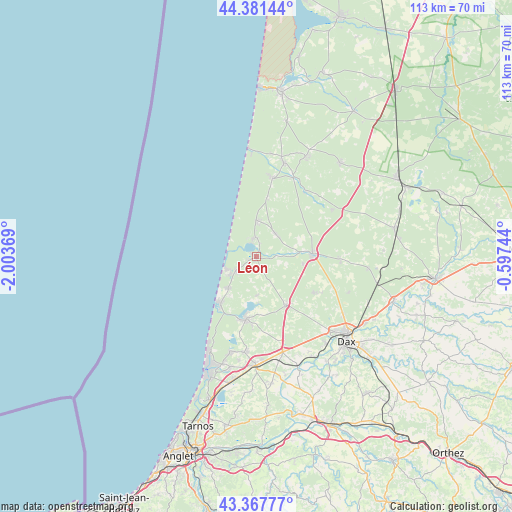
Léon GPS coordinates[2]
43° 52' 36.336" North, 1° 18' 2.052" West
| Map corner | latitude | longitude |
|---|---|---|
| Upper-left | 44.38144°, | -2.00369° |
| Center: | 43.87676°, | -1.30057° |
| Lower-right: | 43.36777°, | -0.59744° |
| Map W x H: | 112.7×112.7 km | = 70×70mi |
| max Lat: | 51.07786° ⇑88.4% North |
| Léon: | 43.87676° |
| min Lat: | ⇓11.6% South 41.3874° |
| min Long | Léon | max Long |
| -5.08615° | -1.30057° | 9.52242° |
| W 9.2%⇐ | ⇒90.8% E |
Elevation
Elevation of Léon is 15 m = 49 ft, and this is 178.7 m = 586 ft below average elevation for this country.
| Max E: |
2333 m = 7654 ft | 95.7% |
| Avg. | 193.7 m = 635 ft | |
| Léon | 15 m = 49 ft | |
Min E: |
-1 m = -3 ft | 4.3% |
See also: France elevation on elevation.city.
Geographical zone
Léon is located in North temperate zone (between Tropic of Cancer and the Arctic Circle). Distance of this Northern Tropic circle is 2272.7 km =1412.2 mi to South.| Distance of | km | miles | from Léon |
|---|---|---|---|
| North Pole | 5128.4 | 3186.6 | to North |
| Arctic Circle | 2522.5 | 1567.4 | to North |
| Tropic Cancer | 2272.7 | 1412.2 | to South |
| Equator | 4878.6 | 3031.4 | to South |


Nearby cities:
15 places around Léon: (largest is in red/bold)
• Castets
12.4 km =7.7 mi,  87°
87°
• Herm
14.8 km =9.2 mi,  122°
122°
• Lesperon
19.6 km =12.2 mi,  58°
58°
• Linxe
6.5 km =4 mi,  42°
42°
• Lit-et-Mixe
17.8 km =11.1 mi,  12°
12°
• Magescq
12.5 km =7.8 mi,  147°
147°
• Messanges
9.3 km =5.8 mi,  221°
221°
• Moliets-et-Maa
5.6 km =3.5 mi,  236°
236°
• Saint-Geours-de-Maremne
21.6 km =13.4 mi,  164°
164°
• Saint-Julien-en-Born
21.6 km =13.4 mi,  16°
16°
• Seignosse
21.7 km =13.5 mi,  194°
194°
• Soustons
13.9 km =8.6 mi, 189°
• Tosse
21 km =13 mi, 187°
• Vielle-Saint-Girons
8.1 km =5 mi,  0°
0°
• Vieux-Boucau-les-Bains
12.5 km =7.8 mi, 219°
Sources, notices
• [Note1] Compared only with cities in France existing in our database
• [Src1] Map data: © OpenStreetMap contributors (CC-BY-SA)
• [Src2] Other city data from geonames.org with taken over terms of usage.
• [Src3] Geographical zone / Annual Mean Temperature by Robert A. Rohde @ Wikipedia
