Cormes geodata
Cormes (Pays de la Loire) is a populated place; located in France in Europe/Paris (GMT+2) time zone. With population of 911 people, there are 9566 cities with bigger population in this country. Compared to other cities in France, 62.3% of cities are located further ↓South; 71.4% of cities are located further →East and 56.2% of cities have higher elevation than Cormes. Note1
Administrative division(s):
- Level 1: Pays de la Loire
- Level 2: Sarthe
- Level 3: Arrondissement de Mamers
- Level 4: Cormes


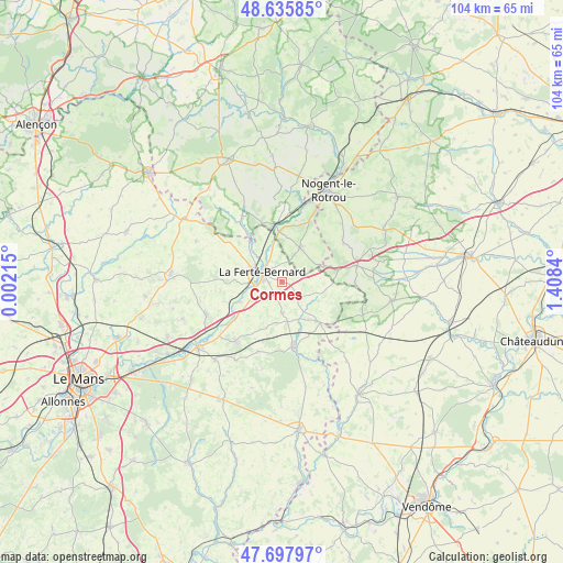
Cormes GPS coordinates[2]
48° 10' 8.58" North, 0° 42' 19.008" East
| Map corner | latitude | longitude |
|---|---|---|
| Upper-left | 48.63585°, | 0.00215° |
| Center: | 48.16905°, | 0.70528° |
| Lower-right: | 47.69797°, | 1.4084° |
| Map W x H: | 104.3×104.3 km | = 64.8×64.8mi |
| max Lat: | 51.07786° ⇑37.7% North |
| Cormes: | 48.16905° |
| min Lat: | ⇓62.3% South 41.3874° |
| min Long | Cormes | max Long |
| -5.08615° | 0.70528° | 9.52242° |
| W 28.6%⇐ | ⇒71.4% E |
Elevation
Elevation of Cormes is 113 m = 371 ft, and this is 80.7 m = 265 ft below average elevation for this country.
| Max E: |
2333 m = 7654 ft | 56.2% |
| Avg. | 193.7 m = 635 ft | |
| Cormes | 113 m = 371 ft | |
Min E: |
-1 m = -3 ft | 43.8% |
See also: France elevation on elevation.city.
Geographical zone
Cormes is located in North temperate zone (between Tropic of Cancer and the Arctic Circle). Distance of this North polar circle is 2045.3 km =1270.9 mi to North.| Distance of | km | miles | from Cormes |
|---|---|---|---|
| North Pole | 4651.2 | 2890.1 | to North |
| Arctic Circle | 2045.3 | 1270.9 | to North |
| Tropic Cancer | 2750 | 1708.8 | to South |
| Equator | 5355.9 | 3328 | to South |


Nearby cities:
15 places around Cormes: (largest is in red/bold)
• Avezé
6.7 km =4.2 mi,  342°
342°
• Boëssé-le-Sec
11.2 km =7 mi,  250°
250°
• Ceton
7.2 km =4.5 mi,  27°
27°
• Cherreau
3.1 km =1.9 mi,  329°
329°
• Cherré
3.5 km =2.2 mi,  276°
276°
• La Chapelle-du-Bois
10.2 km =6.3 mi,  305°
305°
• La Ferté-Bernard
4.3 km =2.7 mi,  296°
296°
• Lamnay
5.7 km =3.5 mi,  178°
178°
• Melleray
10.5 km =6.5 mi,  137°
137°
• Mâle
11.6 km =7.2 mi,  12°
12°
• Préval
9.5 km =5.9 mi,  320°
320°
• Saint-Aubin-des-Coudrais
8.9 km =5.5 mi,  271°
271°
• Saint-Maixent
9.7 km =6 mi,  203°
203°
• Sceaux-sur-Huisne
11.4 km =7.1 mi,  231°
231°
• Vibraye
12.9 km =8 mi,  167°
167°
Sources, notices
• [Note1] Compared only with cities in France existing in our database
• [Src1] Map data: © OpenStreetMap contributors (CC-BY-SA)
• [Src2] Other city data from geonames.org with taken over terms of usage.
• [Src3] Geographical zone / Annual Mean Temperature by Robert A. Rohde @ Wikipedia
