Lavaré geodata
Lavaré (Pays de la Loire) is a populated place; located in France in Europe/Paris (GMT+2) time zone. With population of 767 people, there are 10982 cities with bigger population in this country. Compared to other cities in France, 60.3% of cities are located further ↓South; 71.9% of cities are located further →East and 54.1% of cities have higher elevation than Lavaré. Note1
Administrative division(s):
- Level 1: Pays de la Loire
- Level 2: Sarthe
- Level 3: Arrondissement de Mamers
- Level 4: Lavaré


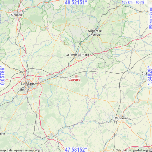
Lavaré GPS coordinates[2]
48° 3' 13.176" North, 0° 38' 42.576" East
| Map corner | latitude | longitude |
|---|---|---|
| Upper-left | 48.52151°, | -0.05796° |
| Center: | 48.05366°, | 0.64516° |
| Lower-right: | 47.58152°, | 1.34829° |
| Map W x H: | 104.5×104.5 km | = 64.9×64.9mi |
| max Lat: | 51.07786° ⇑39.7% North |
| Lavaré: | 48.05366° |
| min Lat: | ⇓60.3% South 41.3874° |
| min Long | Lavaré | max Long |
| -5.08615° | 0.64516° | 9.52242° |
| W 28.1%⇐ | ⇒71.9% E |
Elevation
Elevation of Lavaré is 119 m = 390 ft, and this is 74.7 m = 245 ft below average elevation for this country.
| Max E: |
2333 m = 7654 ft | 54.1% |
| Avg. | 193.7 m = 635 ft | |
| Lavaré | 119 m = 390 ft | |
Min E: |
-1 m = -3 ft | 45.9% |
See also: France elevation on elevation.city.
Geographical zone
Lavaré is located in North temperate zone (between Tropic of Cancer and the Arctic Circle). Distance of this North polar circle is 2058.1 km =1278.8 mi to North.| Distance of | km | miles | from Lavaré |
|---|---|---|---|
| North Pole | 4664 | 2898.1 | to North |
| Arctic Circle | 2058.1 | 1278.8 | to North |
| Tropic Cancer | 2737.1 | 1700.8 | to South |
| Equator | 5343.1 | 3320 | to South |


Nearby cities:
15 places around Lavaré: (largest is in red/bold)
• Bouloire
11.3 km =7 mi,  218°
218°
• Boëssé-le-Sec
10.9 km =6.8 mi,  326°
326°
• Connerré
11.3 km =7 mi,  271°
271°
• Coudrecieux
6.9 km =4.3 mi,  190°
190°
• Dollon
4.6 km =2.9 mi,  249°
249°
• Duneau
9.4 km =5.8 mi,  279°
279°
• Lamnay
8.4 km =5.2 mi,  32°
32°
• Le Luart
4.8 km =3 mi,  292°
292°
• Melleray
12.6 km =7.8 mi,  66°
66°
• Saint-Maixent
4 km =2.5 mi,  8°
8°
• Saint-Michel-de-Chavaignes
6.7 km =4.2 mi,  234°
234°
• Sceaux-sur-Huisne
7.2 km =4.5 mi,  321°
321°
• Thorigné-sur-Dué
8.3 km =5.2 mi,  258°
258°
• Tuffé
11.7 km =7.3 mi,  304°
304°
• Vibraye
7.2 km =4.5 mi,  87°
87°
Sources, notices
• [Note1] Compared only with cities in France existing in our database
• [Src1] Map data: © OpenStreetMap contributors (CC-BY-SA)
• [Src2] Other city data from geonames.org with taken over terms of usage.
• [Src3] Geographical zone / Annual Mean Temperature by Robert A. Rohde @ Wikipedia
