Saint-Michel-de-Chavaignes geodata
Saint-Michel-de-Chavaignes (Pays de la Loire) is a populated place; located in France in Europe/Paris (GMT+2) time zone. With population of 760 people, there are 11054 cities with bigger population in this country. Compared to other cities in France, 59.6% of cities are located further ↓South; 72.7% of cities are located further →East and 59.7% of cities have higher elevation than Saint-Michel-de-Chavaignes. Note1
Administrative division(s):
- Level 1: Pays de la Loire
- Level 2: Sarthe
- Level 3: Arrondissement de Mamers
- Level 4: Saint-Michel-de-Chavaignes
Current local time in Saint-Michel-de-Chavaignes:
11:25 AM, SaturdayDifference from your time zone: hours


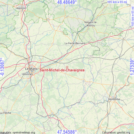
Saint-Michel-de-Chavaignes GPS coordinates[2]
48° 1' 5.952" North, 0° 34' 20.136" East
| Map corner | latitude | longitude |
|---|---|---|
| Upper-left | 48.48649°, | -0.13087° |
| Center: | 48.01832°, | 0.57226° |
| Lower-right: | 47.54586°, | 1.27539° |
| Map W x H: | 104.6×104.6 km | = 65×65mi |
| max Lat: | 51.07786° ⇑40.4% North |
| Saint-Michel-de-Chavaignes: | 48.01832° |
| min Lat: | ⇓59.6% South 41.3874° |
| min Long | Saint-Michel-de | max Long |
| -5.08615° | 0.57226° | 9.52242° |
| W 27.3%⇐ | ⇒72.7% E |
Elevation
Elevation of Saint-Michel-de-Chavaignes is 103 m = 338 ft, and this is 90.7 m = 298 ft below average elevation for this country.
| Max E: |
2333 m = 7654 ft | 59.7% |
| Avg. | 193.7 m = 635 ft | |
| Saint-Michel-de-Chavaignes | 103 m = 338 ft | |
Min E: |
-1 m = -3 ft | 40.3% |
See also: France elevation on elevation.city.
Geographical zone
Saint-Michel-de-Chavaignes is located in North temperate zone (between Tropic of Cancer and the Arctic Circle). Distance of this North polar circle is 2062 km =1281.3 mi to North.| Distance of | km | miles | from Saint-Michel-de-Chavaignes |
|---|---|---|---|
| North Pole | 4667.9 | 2900.5 | to North |
| Arctic Circle | 2062 | 1281.3 | to North |
| Tropic Cancer | 2733.2 | 1698.3 | to South |
| Equator | 5339.1 | 3317.6 | to South |


Nearby cities:
15 places around Saint-Michel-de-Chavaignes: (largest is in red/bold)
• Bouloire
5.2 km =3.2 mi,  198°
198°
• Connerré
7.3 km =4.5 mi,  306°
306°
• Coudrecieux
5.1 km =3.2 mi,  123°
123°
• Dollon
2.5 km =1.6 mi,  25°
25°
• Duneau
6.8 km =4.2 mi,  325°
325°
• Lavaré
6.7 km =4.2 mi,  54°
54°
• Le Breil-sur-Mérize
7.1 km =4.4 mi,  260°
260°
• Le Luart
5.9 km =3.7 mi,  9°
9°
• Montfort-le-Gesnois
12.1 km =7.5 mi,  286°
286°
• Saint-Maixent
9.9 km =6.2 mi,  37°
37°
• Sceaux-sur-Huisne
9.7 km =6 mi, 5°
• Soulitré
8.7 km =5.4 mi, 264°
• Thorigné-sur-Dué
3.6 km =2.2 mi, 310°
• Tuffé
11.4 km =7.1 mi,  338°
338°
• Volnay
12.2 km =7.6 mi,  219°
219°
Sources, notices
• [Note1] Compared only with cities in France existing in our database
• [Src1] Map data: © OpenStreetMap contributors (CC-BY-SA)
• [Src2] Other city data from geonames.org with taken over terms of usage.
• [Src3] Geographical zone / Annual Mean Temperature by Robert A. Rohde @ Wikipedia
