Mareuil geodata
Mareuil (Nouvelle-Aquitaine) is a populated place; located in France in Europe/Paris (GMT+2) time zone. With population of 1,174 people, there are 7680 cities with bigger population in this country. Compared to other cities in France, 74.7% of cities are located further ↑North; 73.9% of cities are located further →East and 54.4% of cities have higher elevation than Mareuil. Note1
Administrative division(s):
- Level 1: Nouvelle-Aquitaine
- Level 2: Dordogne
- Level 3: Arrondissement de Nontron
- Level 4: Mareuil en Périgord


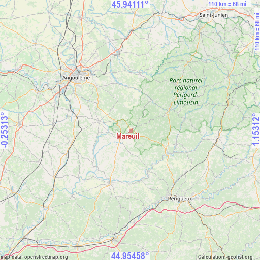
Mareuil GPS coordinates[2]
45° 27' 0" North, 0° 27' 0" East
| Map corner | latitude | longitude |
|---|---|---|
| Upper-left | 45.94111°, | -0.25313° |
| Center: | 45.45°, | 0.45° |
| Lower-right: | 44.95458°, | 1.15312° |
| Map W x H: | 109.7×109.7 km | = 68.2×68.2mi |
| max Lat: | 51.07786° ⇑74.7% North |
| Mareuil: | 45.45° |
| min Lat: | ⇓25.3% South 41.3874° |
| min Long | Mareuil | max Long |
| -5.08615° | 0.45° | 9.52242° |
| W 26.1%⇐ | ⇒73.9% E |
Elevation
Elevation of Mareuil is 118 m = 387 ft, and this is 75.7 m = 248 ft below average elevation for this country.
| Max E: |
2333 m = 7654 ft | 54.4% |
| Avg. | 193.7 m = 635 ft | |
| Mareuil | 118 m = 387 ft | |
Min E: |
-1 m = -3 ft | 45.6% |
See also: France elevation on elevation.city.
Geographical zone
Mareuil is located in North temperate zone (between Tropic of Cancer and the Arctic Circle). Distance of this North polar circle is 2347.6 km =1458.7 mi to North.| Distance of | km | miles | from Mareuil |
|---|---|---|---|
| North Pole | 4953.5 | 3078 | to North |
| Arctic Circle | 2347.6 | 1458.7 | to North |
| Tropic Cancer | 2447.6 | 1520.9 | to South |
| Equator | 5053.6 | 3140.2 | to South |


Nearby cities:
15 places around Mareuil: (largest is in red/bold)
• Bourdeilles
17.8 km =11.1 mi,  143°
143°
• Brantôme
18.8 km =11.7 mi,  121°
121°
• Celles
17.2 km =10.7 mi,  189°
189°
• Dignac
17.1 km =10.6 mi,  310°
310°
• Grand-Brassac
18.7 km =11.6 mi,  172°
172°
• Javerlhac-et-la-Chapelle-Saint-Robert
15.9 km =9.9 mi,  32°
32°
• Marthon
18.3 km =11.4 mi,  358°
358°
• Nontron
18.7 km =11.6 mi,  61°
61°
• Ronsenac
17.3 km =10.7 mi,  282°
282°
• Rougnac
12.1 km =7.5 mi,  319°
319°
• Saint-Martial-de-Valette
17.3 km =10.7 mi, 64°
• Sers
19.6 km =12.2 mi,  328°
328°
• Verteillac
13.2 km =8.2 mi,  209°
209°
• Villebois-Lavalette
13.5 km =8.4 mi,  285°
285°
• Vouzan
18.4 km =11.4 mi, 334°
Sources, notices
• [Note1] Compared only with cities in France existing in our database
• [Src1] Map data: © OpenStreetMap contributors (CC-BY-SA)
• [Src2] Other city data from geonames.org with taken over terms of usage.
• [Src3] Geographical zone / Annual Mean Temperature by Robert A. Rohde @ Wikipedia
