Véron geodata
Véron (Bourgogne-Franche-Comté) is a populated place; located in France in Europe/Paris (GMT+2) time zone. With population of 1,724 people, there are 5466 cities with bigger population in this country. Compared to other cities in France, 61.6% of cities are located further ↓South; 62.1% of cities are located further ←West and 71.4% of cities have higher elevation than Véron. Note1
Administrative division(s):
- Level 1: Bourgogne-Franche-Comté
- Level 2: Département de l'Yonne
- Level 3: Arrondissement de Sens
- Level 4: Véron


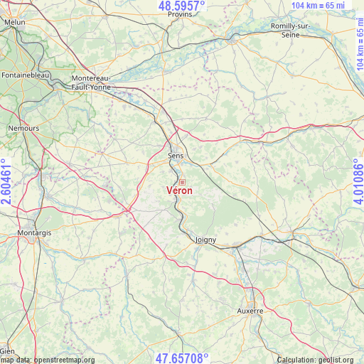
Véron GPS coordinates[2]
48° 7' 42.708" North, 3° 18' 27.828" East
| Map corner | latitude | longitude |
|---|---|---|
| Upper-left | 48.5957°, | 2.60461° |
| Center: | 48.12853°, | 3.30773° |
| Lower-right: | 47.65708°, | 4.01086° |
| Map W x H: | 104.4×104.4 km | = 64.9×64.9mi |
| max Lat: | 51.07786° ⇑38.4% North |
| Véron: | 48.12853° |
| min Lat: | ⇓61.6% South 41.3874° |
| min Long | Véron | max Long |
| -5.08615° | 3.30773° | 9.52242° |
| W 62.1%⇐ | ⇒37.9% E |
Elevation
Elevation of Véron is 75 m = 246 ft, and this is 118.7 m = 389 ft below average elevation for this country.
| Max E: |
2333 m = 7654 ft | 71.4% |
| Avg. | 193.7 m = 635 ft | |
| Véron | 75 m = 246 ft | |
Min E: |
-1 m = -3 ft | 28.6% |
See also: France elevation on elevation.city.
Geographical zone
Véron is located in North temperate zone (between Tropic of Cancer and the Arctic Circle). Distance of this North polar circle is 2049.8 km =1273.7 mi to North.| Distance of | km | miles | from Véron |
|---|---|---|---|
| North Pole | 4655.7 | 2892.9 | to North |
| Arctic Circle | 2049.8 | 1273.7 | to North |
| Tropic Cancer | 2745.5 | 1706 | to South |
| Equator | 5351.4 | 3325.2 | to South |


Nearby cities:
15 places around Véron: (largest is in red/bold)
• Armeau
9.2 km =5.7 mi,  173°
173°
• Chaumot
8.5 km =5.3 mi,  231°
231°
• Collemiers
6.3 km =3.9 mi,  299°
299°
• Dixmont
9.4 km =5.8 mi,  123°
123°
• Gron
4.8 km =3 mi,  316°
316°
• Maillot
5.2 km =3.2 mi,  0°
0°
• Malay-le-Grand
5.8 km =3.6 mi,  25°
25°
• Marsangy
4.2 km =2.6 mi,  240°
240°
• Paron
7 km =4.3 mi, 322°
• Saint-Clément
9.9 km =6.2 mi,  354°
354°
• Sens
7.9 km =4.9 mi, 346°
• Theil-sur-Vanne
9.8 km =6.1 mi,  64°
64°
• Villeneuve-sur-Yonne
5.2 km =3.2 mi,  188°
188°
• Égriselles-le-Bocage
9.3 km =5.8 mi,  264°
264°
• Étigny
1.7 km =1.1 mi, 316°
Sources, notices
• [Note1] Compared only with cities in France existing in our database
• [Src1] Map data: © OpenStreetMap contributors (CC-BY-SA)
• [Src2] Other city data from geonames.org with taken over terms of usage.
• [Src3] Geographical zone / Annual Mean Temperature by Robert A. Rohde @ Wikipedia
