Sens geodata
Sens (Bourgogne-Franche-Comté) is a seat of a third-order administrative division; located in France in Europe/Paris (GMT+2) time zone. With population of 28,700 people, there are 294 cities with bigger population in this country. Compared to other cities in France, 62.8% of cities are located further ↓South; 61.8% of cities are located further ←West and 72.6% of cities have higher elevation than Sens. Note1
Administrative division(s):
- Level 1: Bourgogne-Franche-Comté
- Level 2: Département de l'Yonne
- Level 3: Arrondissement de Sens
- Level 4: Sens


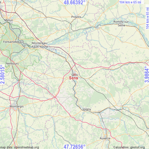
Sens GPS coordinates[2]
48° 11' 50.568" North, 3° 16' 59.808" East
| Map corner | latitude | longitude |
|---|---|---|
| Upper-left | 48.66392°, | 2.58015° |
| Center: | 48.19738°, | 3.28328° |
| Lower-right: | 47.72656°, | 3.9864° |
| Map W x H: | 104.2×104.2 km | = 64.7×64.7mi |
| max Lat: | 51.07786° ⇑37.2% North |
| Sens: | 48.19738° |
| min Lat: | ⇓62.8% South 41.3874° |
| min Long | Sens | max Long |
| -5.08615° | 3.28328° | 9.52242° |
| W 61.8%⇐ | ⇒38.2% E |
Elevation
Elevation of Sens is 72 m = 236 ft, and this is 121.7 m = 399 ft below average elevation for this country.
| Max E: |
2333 m = 7654 ft | 72.6% |
| Avg. | 193.7 m = 635 ft | |
| Sens | 72 m = 236 ft | |
Min E: |
-1 m = -3 ft | 27.4% |
See also: France elevation on elevation.city.
Geographical zone
Sens is located in North temperate zone (between Tropic of Cancer and the Arctic Circle). Distance of this North polar circle is 2042.1 km =1268.9 mi to North.| Distance of | km | miles | from Sens |
|---|---|---|---|
| North Pole | 4648 | 2888.1 | to North |
| Arctic Circle | 2042.1 | 1268.9 | to North |
| Tropic Cancer | 2753.1 | 1710.7 | to South |
| Equator | 5359 | 3329.9 | to South |


Nearby cities:
15 places around Sens: (largest is in red/bold)
• Collemiers
5.9 km =3.7 mi,  218°
218°
• Courtois-sur-Yonne
3.9 km =2.4 mi,  327°
327°
• Cuy
6.8 km =4.2 mi,  349°
349°
• Fontaine-la-Gaillarde
7.5 km =4.7 mi,  70°
70°
• Gron
4.4 km =2.7 mi,  199°
199°
• Maillot
3 km =1.9 mi,  143°
143°
• Malay-le-Grand
5 km =3.1 mi,  118°
118°
• Paron
3.2 km =2 mi,  229°
229°
• Saint-Clément
2.4 km =1.5 mi,  23°
23°
• Saint-Denis-lès-Sens
3.6 km =2.2 mi,  339°
339°
• Saint-Martin-du-Tertre
2.7 km =1.7 mi,  322°
322°
• Saligny
5.4 km =3.4 mi, 70°
• Soucy
6.5 km =4 mi,  27°
27°
• Véron
7.9 km =4.9 mi,  166°
166°
• Étigny
6.5 km =4 mi, 174°
Sources, notices
• [Note1] Compared only with cities in France existing in our database
• [Src1] Map data: © OpenStreetMap contributors (CC-BY-SA)
• [Src2] Other city data from geonames.org with taken over terms of usage.
• [Src3] Geographical zone / Annual Mean Temperature by Robert A. Rohde @ Wikipedia
