Vernou-la-Celle-sur-Seine geodata
Vernou-la-Celle-sur-Seine (Île-de-France) is a populated place; located in France in Europe/Paris (GMT+2) time zone. With population of 2,742 people, there are 3576 cities with bigger population in this country. Compared to other cities in France, 66.1% of cities are located further ↓South; 55.6% of cities are located further ←West and 71% of cities have higher elevation than Vernou-la-Celle-sur-Seine. Note1
Administrative division(s):
- Level 1: Île-de-France
- Level 2: Seine-et-Marne
- Level 3: Arrondissement de Fontainebleau
- Level 4: Vernou-la-Celle-sur-Seine
Current local time in Vernou-la-Celle-sur-Seine:
08:37 AM, SaturdayDifference from your time zone: hours


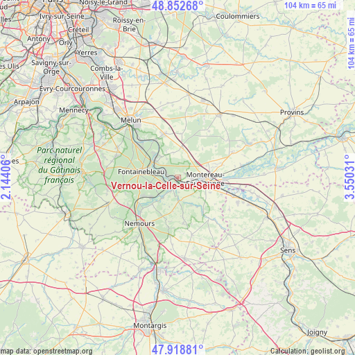
Vernou-la-Celle-sur-Seine GPS coordinates[2]
48° 23' 16.404" North, 2° 50' 49.848" East
| Map corner | latitude | longitude |
|---|---|---|
| Upper-left | 48.85268°, | 2.14406° |
| Center: | 48.38789°, | 2.84718° |
| Lower-right: | 47.91881°, | 3.55031° |
| Map W x H: | 103.8×103.8 km | = 64.5×64.5mi |
| max Lat: | 51.07786° ⇑33.9% North |
| Vernou-la-Celle-sur-Seine: | 48.38789° |
| min Lat: | ⇓66.1% South 41.3874° |
| min Long | Vernou-la-Celle | max Long |
| -5.08615° | 2.84718° | 9.52242° |
| W 55.6%⇐ | ⇒44.4% E |
Elevation
Elevation of Vernou-la-Celle-sur-Seine is 76 m = 249 ft, and this is 117.7 m = 386 ft below average elevation for this country.
| Max E: |
2333 m = 7654 ft | 71% |
| Avg. | 193.7 m = 635 ft | |
| Vernou-la-Celle-sur-Seine | 76 m = 249 ft | |
Min E: |
-1 m = -3 ft | 29% |
See also: France elevation on elevation.city.
Geographical zone
Vernou-la-Celle-sur-Seine is located in North temperate zone (between Tropic of Cancer and the Arctic Circle). Distance of this North polar circle is 2020.9 km =1255.7 mi to North.| Distance of | km | miles | from Vernou-la-Celle-sur-Seine |
|---|---|---|---|
| North Pole | 4626.8 | 2875 | to North |
| Arctic Circle | 2020.9 | 1255.7 | to North |
| Tropic Cancer | 2774.3 | 1723.9 | to South |
| Equator | 5380.2 | 3343.1 | to South |


Nearby cities:
15 places around Vernou-la-Celle-sur-Seine: (largest is in red/bold)
• Champagne-sur-Seine
3.8 km =2.4 mi,  287°
287°
• La Grande-Paroisse
4 km =2.5 mi,  91°
91°
• Machault
7.6 km =4.7 mi,  351°
351°
• Montereau-Fault-Yonne
7.6 km =4.7 mi, 93°
• Moret-sur-Loing
2.8 km =1.7 mi,  232°
232°
• Saint-Mammès
2.3 km =1.4 mi,  260°
260°
• Thomery
4.8 km =3 mi,  296°
296°
• Valence-en-Brie
6.9 km =4.3 mi,  27°
27°
• Varennes-sur-Seine
6 km =3.7 mi,  105°
105°
• Veneux-les-Sablons
4 km =2.5 mi, 255°
• Ville-Saint-Jacques
6.3 km =3.9 mi,  142°
142°
• Villecerf
6.7 km =4.2 mi,  179°
179°
• Vulaines-sur-Seine
7.8 km =4.8 mi,  308°
308°
• Écuelles
3.9 km =2.4 mi,  206°
206°
• Épisy
7.4 km =4.6 mi,  217°
217°
Sources, notices
• [Note1] Compared only with cities in France existing in our database
• [Src1] Map data: © OpenStreetMap contributors (CC-BY-SA)
• [Src2] Other city data from geonames.org with taken over terms of usage.
• [Src3] Geographical zone / Annual Mean Temperature by Robert A. Rohde @ Wikipedia
