Vulaines-sur-Seine geodata
Vulaines-sur-Seine (Île-de-France) is a populated place; located in France in Europe/Paris (GMT+2) time zone. With population of 2,273 people, there are 4236 cities with bigger population in this country. Compared to other cities in France, 66.9% of cities are located further ↓South; 54.4% of cities are located further ←West and 64.9% of cities have higher elevation than Vulaines-sur-Seine. Note1
Administrative division(s):
- Level 1: Île-de-France
- Level 2: Seine-et-Marne
- Level 3: Arrondissement de Fontainebleau
- Level 4: Vulaines-sur-Seine


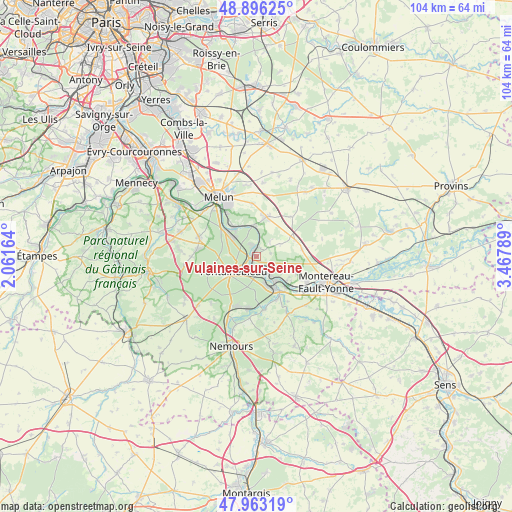
Vulaines-sur-Seine GPS coordinates[2]
48° 25' 54.696" North, 2° 45' 53.136" East
| Map corner | latitude | longitude |
|---|---|---|
| Upper-left | 48.89625°, | 2.06164° |
| Center: | 48.43186°, | 2.76476° |
| Lower-right: | 47.96319°, | 3.46789° |
| Map W x H: | 103.7×103.7 km | = 64.4×64.4mi |
| max Lat: | 51.07786° ⇑33.1% North |
| Vulaines-sur-Seine: | 48.43186° |
| min Lat: | ⇓66.9% South 41.3874° |
| min Long | Vulaines-sur-Se | max Long |
| -5.08615° | 2.76476° | 9.52242° |
| W 54.4%⇐ | ⇒45.6% E |
Elevation
Elevation of Vulaines-sur-Seine is 90 m = 295 ft, and this is 103.7 m = 340 ft below average elevation for this country.
| Max E: |
2333 m = 7654 ft | 64.9% |
| Avg. | 193.7 m = 635 ft | |
| Vulaines-sur-Seine | 90 m = 295 ft | |
Min E: |
-1 m = -3 ft | 35.1% |
See also: France elevation on elevation.city.
Geographical zone
Vulaines-sur-Seine is located in North temperate zone (between Tropic of Cancer and the Arctic Circle). Distance of this North polar circle is 2016.1 km =1252.7 mi to North.| Distance of | km | miles | from Vulaines-sur-Seine |
|---|---|---|---|
| North Pole | 4621.9 | 2871.9 | to North |
| Arctic Circle | 2016.1 | 1252.7 | to North |
| Tropic Cancer | 2779.2 | 1726.9 | to South |
| Equator | 5385.1 | 3346.1 | to South |


Nearby cities:
15 places around Vulaines-sur-Seine: (largest is in red/bold)
• Avon
4.7 km =2.9 mi,  224°
224°
• Bois-le-Roi
6.4 km =4 mi,  316°
316°
• Champagne-sur-Seine
4.5 km =2.8 mi,  147°
147°
• Fontaine-le-Port
6 km =3.7 mi,  0°
0°
• Fontainebleau
5.3 km =3.3 mi,  241°
241°
• Féricy
4.1 km =2.5 mi,  40°
40°
• Héricy
1.8 km =1.1 mi,  359°
359°
• Machault
5.6 km =3.5 mi,  61°
61°
• Moret-sur-Loing
7.7 km =4.8 mi, 149°
• Saint-Mammès
6.5 km =4 mi,  144°
144°
• Samois-sur-Seine
2.5 km =1.6 mi,  335°
335°
• Samoreau
0.7 km =0.4 mi,  247°
247°
• Thomery
3.3 km =2.1 mi, 147°
• Veneux-les-Sablons
6.3 km =3.9 mi,  159°
159°
• Vernou-la-Celle-sur-Seine
7.8 km =4.8 mi,  128°
128°
Sources, notices
• [Note1] Compared only with cities in France existing in our database
• [Src1] Map data: © OpenStreetMap contributors (CC-BY-SA)
• [Src2] Other city data from geonames.org with taken over terms of usage.
• [Src3] Geographical zone / Annual Mean Temperature by Robert A. Rohde @ Wikipedia
