Champagne-sur-Seine geodata
Champagne-sur-Seine (Île-de-France) is a populated place; located in France in Europe/Paris (GMT+2) time zone. With population of 6,608 people, there are 1493 cities with bigger population in this country. Compared to other cities in France, 66.3% of cities are located further ↓South; 54.9% of cities are located further ←West and 81.1% of cities have higher elevation than Champagne-sur-Seine. Note1
Administrative division(s):
- Level 1: Île-de-France
- Level 2: Seine-et-Marne
- Level 3: Arrondissement de Fontainebleau
- Level 4: Champagne-sur-Seine


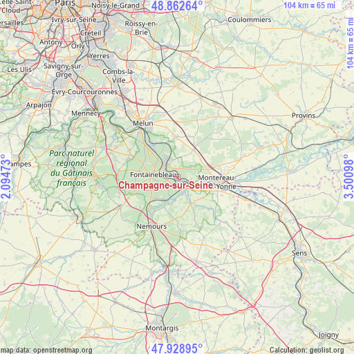
Champagne-sur-Seine GPS coordinates[2]
48° 23' 52.584" North, 2° 47' 52.26" East
| Map corner | latitude | longitude |
|---|---|---|
| Upper-left | 48.86264°, | 2.09473° |
| Center: | 48.39794°, | 2.79785° |
| Lower-right: | 47.92895°, | 3.50098° |
| Map W x H: | 103.8×103.8 km | = 64.5×64.5mi |
| max Lat: | 51.07786° ⇑33.7% North |
| Champagne-sur-Seine: | 48.39794° |
| min Lat: | ⇓66.3% South 41.3874° |
| min Long | Champagne-sur-S | max Long |
| -5.08615° | 2.79785° | 9.52242° |
| W 54.9%⇐ | ⇒45.1% E |
Elevation
Elevation of Champagne-sur-Seine is 52 m = 171 ft, and this is 141.7 m = 465 ft below average elevation for this country.
| Max E: |
2333 m = 7654 ft | 81.1% |
| Avg. | 193.7 m = 635 ft | |
| Champagne-sur-Seine | 52 m = 171 ft | |
Min E: |
-1 m = -3 ft | 18.9% |
See also: France elevation on elevation.city.
Geographical zone
Champagne-sur-Seine is located in North temperate zone (between Tropic of Cancer and the Arctic Circle). Distance of this North polar circle is 2019.8 km =1255 mi to North.| Distance of | km | miles | from Champagne-sur-Seine |
|---|---|---|---|
| North Pole | 4625.7 | 2874.3 | to North |
| Arctic Circle | 2019.8 | 1255 | to North |
| Tropic Cancer | 2775.4 | 1724.6 | to South |
| Equator | 5381.3 | 3343.8 | to South |


Nearby cities:
15 places around Champagne-sur-Seine: (largest is in red/bold)
• Avon
5.8 km =3.6 mi,  274°
274°
• Fontainebleau
7.2 km =4.5 mi,  279°
279°
• Féricy
6.9 km =4.3 mi,  1°
1°
• Héricy
6.1 km =3.8 mi,  336°
336°
• Machault
6.9 km =4.3 mi,  21°
21°
• Moret-sur-Loing
3.2 km =2 mi,  153°
153°
• Saint-Mammès
2 km =1.2 mi,  138°
138°
• Samois-sur-Seine
7 km =4.3 mi,  330°
330°
• Samoreau
4.7 km =2.9 mi,  318°
318°
• Thomery
1.2 km =0.7 mi, 326°
• Veneux-les-Sablons
2.1 km =1.3 mi,  185°
185°
• Vernou-la-Celle-sur-Seine
3.8 km =2.4 mi,  107°
107°
• Vulaines-sur-Seine
4.5 km =2.8 mi, 327°
• Écuelles
5 km =3.1 mi,  157°
157°
• Épisy
7.1 km =4.4 mi, 186°
Sources, notices
• [Note1] Compared only with cities in France existing in our database
• [Src1] Map data: © OpenStreetMap contributors (CC-BY-SA)
• [Src2] Other city data from geonames.org with taken over terms of usage.
• [Src3] Geographical zone / Annual Mean Temperature by Robert A. Rohde @ Wikipedia
