Verneuil-sur-Avre geodata
Verneuil-sur-Avre (Normandy) is a populated place; located in France in Europe/Paris (GMT+2) time zone. With population of 7,229 people, there are 1349 cities with bigger population in this country. Compared to other cities in France, 74.1% of cities are located further ↓South; 69.4% of cities are located further →East and 61.3% of cities have lower elevation than Verneuil-sur-Avre. Note1
Administrative division(s):
- Level 1: Normandy
- Level 2: Département de l'Eure
- Level 3: Arrondissement de Bernay
- Level 4: Verneuil d'Avre et d'Iton


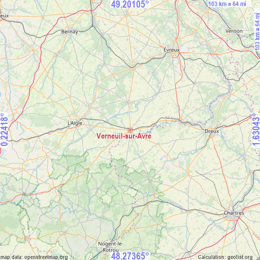
Verneuil-sur-Avre GPS coordinates[2]
48° 44' 22.164" North, 0° 55' 38.316" East
| Map corner | latitude | longitude |
|---|---|---|
| Upper-left | 49.20105°, | 0.22418° |
| Center: | 48.73949°, | 0.92731° |
| Lower-right: | 48.27365°, | 1.63043° |
| Map W x H: | 103.1×103.1 km | = 64.1×64.1mi |
| max Lat: | 51.07786° ⇑25.9% North |
| Verneuil-sur-Avre: | 48.73949° |
| min Lat: | ⇓74.1% South 41.3874° |
| min Long | Verneuil-sur-Av | max Long |
| -5.08615° | 0.92731° | 9.52242° |
| W 30.6%⇐ | ⇒69.4% E |
Elevation
Elevation of Verneuil-sur-Avre is 176 m = 577 ft, and this is 17.7 m = 58 ft below average elevation for this country.
| Max E: |
2333 m = 7654 ft | 38.7% |
| Avg. | 193.7 m = 635 ft | |
| Verneuil-sur-Avre | 176 m = 577 ft | |
Min E: |
-1 m = -3 ft | 61.3% |
See also: France elevation on elevation.city.
Geographical zone
Verneuil-sur-Avre is located in North temperate zone (between Tropic of Cancer and the Arctic Circle). Distance of this North polar circle is 1981.9 km =1231.5 mi to North.| Distance of | km | miles | from Verneuil-sur-Avre |
|---|---|---|---|
| North Pole | 4587.7 | 2850.7 | to North |
| Arctic Circle | 1981.9 | 1231.5 | to North |
| Tropic Cancer | 2813.4 | 1748.2 | to South |
| Equator | 5419.3 | 3367.4 | to South |


Nearby cities:
15 places around Verneuil-sur-Avre: (largest is in red/bold)
• Bois-Arnault
16.7 km =10.4 mi,  300°
300°
• Boissy-lès-Perche
6.6 km =4.1 mi,  204°
204°
• Bourth
9.2 km =5.7 mi,  290°
290°
• Breteuil
10.5 km =6.5 mi,  355°
355°
• Brezolles
12.1 km =7.5 mi,  116°
116°
• Chandai
13.8 km =8.6 mi,  276°
276°
• Dampierre-sur-Avre
16.5 km =10.3 mi,  81°
81°
• Francheville
7.7 km =4.8 mi,  312°
312°
• Gouville
13.2 km =8.2 mi,  20°
20°
• La Ferté-Vidame
14.3 km =8.9 mi,  187°
187°
• La Guéroulde
8.6 km =5.3 mi,  340°
340°
• Piseux
5.1 km =3.2 mi,  42°
42°
• Saint-Maurice-lès-Charencey
16 km =9.9 mi,  230°
230°
• Saint-Ouen-sur-Iton
16.9 km =10.5 mi,  268°
268°
• Tillières-sur-Avre
9.5 km =5.9 mi, 78°
Sources, notices
• [Note1] Compared only with cities in France existing in our database
• [Src1] Map data: © OpenStreetMap contributors (CC-BY-SA)
• [Src2] Other city data from geonames.org with taken over terms of usage.
• [Src3] Geographical zone / Annual Mean Temperature by Robert A. Rohde @ Wikipedia
