Tillières-sur-Avre geodata
Tillières-sur-Avre (Normandy) is a populated place; located in France in Europe/Paris (GMT+2) time zone. With population of 1,252 people, there are 7269 cities with bigger population in this country. Compared to other cities in France, 74.5% of cities are located further ↓South; 68.3% of cities are located further →East and 50.8% of cities have lower elevation than Tillières-sur-Avre. Note1
Administrative division(s):
- Level 1: Normandy
- Level 2: Département de l'Eure
- Level 3: Arrondissement de Bernay
- Level 4: Tillières-sur-Avre


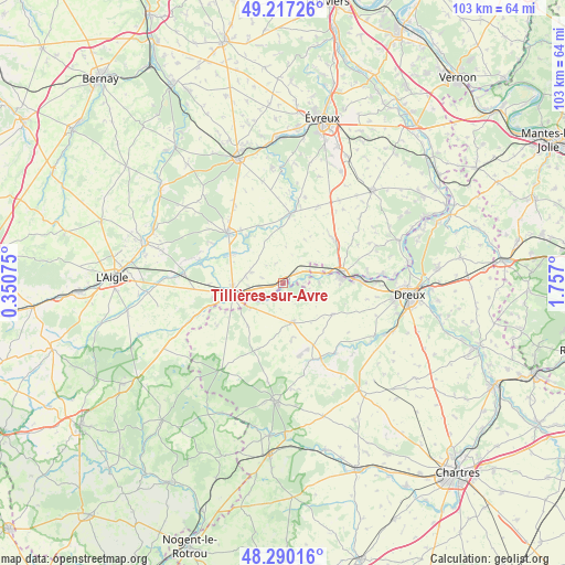
Tillières-sur-Avre GPS coordinates[2]
48° 45' 21.06" North, 1° 3' 13.968" East
| Map corner | latitude | longitude |
|---|---|---|
| Upper-left | 49.21726°, | 0.35075° |
| Center: | 48.75585°, | 1.05388° |
| Lower-right: | 48.29016°, | 1.757° |
| Map W x H: | 103.1×103.1 km | = 64.1×64.1mi |
| max Lat: | 51.07786° ⇑25.5% North |
| Tillières-sur-Avre: | 48.75585° |
| min Lat: | ⇓74.5% South 41.3874° |
| min Long | Tillières-sur- | max Long |
| -5.08615° | 1.05388° | 9.52242° |
| W 31.7%⇐ | ⇒68.3% E |
Elevation
Elevation of Tillières-sur-Avre is 135 m = 443 ft, and this is 58.7 m = 193 ft below average elevation for this country.
| Max E: |
2333 m = 7654 ft | 49.2% |
| Avg. | 193.7 m = 635 ft | |
| Tillières-sur-Avre | 135 m = 443 ft | |
Min E: |
-1 m = -3 ft | 50.8% |
See also: France elevation on elevation.city.
Geographical zone
Tillières-sur-Avre is located in North temperate zone (between Tropic of Cancer and the Arctic Circle). Distance of this North polar circle is 1980 km =1230.3 mi to North.| Distance of | km | miles | from Tillières-sur-Avre |
|---|---|---|---|
| North Pole | 4585.9 | 2849.5 | to North |
| Arctic Circle | 1980 | 1230.3 | to North |
| Tropic Cancer | 2815.2 | 1749.3 | to South |
| Equator | 5421.1 | 3368.5 | to South |


Nearby cities:
15 places around Tillières-sur-Avre: (largest is in red/bold)
• Boissy-lès-Perche
14.4 km =8.9 mi,  236°
236°
• Breteuil
13.2 km =8.2 mi,  310°
310°
• Brezolles
7.4 km =4.6 mi,  168°
168°
• Dampierre-sur-Avre
7 km =4.3 mi,  83°
83°
• Damville
12.7 km =7.9 mi,  6°
6°
• Gouville
11.5 km =7.1 mi,  336°
336°
• La Guéroulde
13.6 km =8.5 mi,  297°
297°
• La Madeleine-de-Nonancourt
11.1 km =6.9 mi, 80°
• Laons
10.7 km =6.6 mi,  122°
122°
• Marcilly-la-Campagne
13.8 km =8.6 mi,  51°
51°
• Nonancourt
10.7 km =6.6 mi, 81°
• Piseux
6.1 km =3.8 mi,  288°
288°
• Saint-Lubin-des-Joncherets
12 km =7.5 mi, 84°
• Saint-Rémy-sur-Avre
14 km =8.7 mi,  87°
87°
• Verneuil-sur-Avre
9.5 km =5.9 mi,  258°
258°
Sources, notices
• [Note1] Compared only with cities in France existing in our database
• [Src1] Map data: © OpenStreetMap contributors (CC-BY-SA)
• [Src2] Other city data from geonames.org with taken over terms of usage.
• [Src3] Geographical zone / Annual Mean Temperature by Robert A. Rohde @ Wikipedia
