Verneuil geodata
Verneuil (Grand Est) is a populated place; located in France in Europe/Paris (GMT+2) time zone. With population of 794 people, there are 10681 cities with bigger population in this country. Compared to other cities in France, 82.1% of cities are located further ↓South; 65.6% of cities are located further ←West and 74.1% of cities have higher elevation than Verneuil. Note1
Administrative division(s):
- Level 1: Grand Est
- Level 2: Marne
- Level 3: Arrondissement d'Épernay
- Level 4: Verneuil


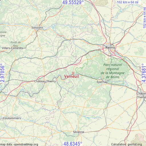
Verneuil GPS coordinates[2]
49° 5' 49.308" North, 3° 40' 25.284" East
| Map corner | latitude | longitude |
|---|---|---|
| Upper-left | 49.55529°, | 2.97056° |
| Center: | 49.09703°, | 3.67369° |
| Lower-right: | 48.6345°, | 4.37681° |
| Map W x H: | 102.4×102.4 km | = 63.6×63.6mi |
| max Lat: | 51.07786° ⇑17.9% North |
| Verneuil: | 49.09703° |
| min Lat: | ⇓82.1% South 41.3874° |
| min Long | Verneuil | max Long |
| -5.08615° | 3.67369° | 9.52242° |
| W 65.6%⇐ | ⇒34.4% E |
Elevation
Elevation of Verneuil is 69 m = 226 ft, and this is 124.7 m = 409 ft below average elevation for this country.
| Max E: |
2333 m = 7654 ft | 74.1% |
| Avg. | 193.7 m = 635 ft | |
| Verneuil | 69 m = 226 ft | |
Min E: |
-1 m = -3 ft | 25.9% |
See also: France elevation on elevation.city.
Geographical zone
Verneuil is located in North temperate zone (between Tropic of Cancer and the Arctic Circle). Distance of this North polar circle is 1942.1 km =1206.8 mi to North.| Distance of | km | miles | from Verneuil |
|---|---|---|---|
| North Pole | 4548 | 2826 | to North |
| Arctic Circle | 1942.1 | 1206.8 | to North |
| Tropic Cancer | 2853.2 | 1772.9 | to South |
| Equator | 5459.1 | 3392.1 | to South |


Nearby cities:
15 places around Verneuil: (largest is in red/bold)
• Beuvardes
14.3 km =8.9 mi,  290°
290°
• Boursault
13.1 km =8.1 mi,  107°
107°
• Châtillon-sur-Marne
6.3 km =3.9 mi,  86°
86°
• Condé-en-Brie
13 km =8.1 mi,  217°
217°
• Crézancy
13.1 km =8.1 mi,  245°
245°
• Dormans
3.6 km =2.2 mi,  225°
225°
• Fossoy
14.9 km =9.3 mi, 248°
• Jaulgonne
10.2 km =6.3 mi,  264°
264°
• Mareuil-le-Port
6.5 km =4 mi, 105°
• Mont-Saint-Père
13.8 km =8.6 mi, 259°
• Port à Binson
6.5 km =4 mi,  104°
104°
• Troissy
3.2 km =2 mi,  123°
123°
• Venteuil
12.3 km =7.6 mi, 97°
• Ville-en-Tardenois
13.1 km =8.1 mi,  44°
44°
• Œuilly
9.8 km =6.1 mi, 110°
Sources, notices
• [Note1] Compared only with cities in France existing in our database
• [Src1] Map data: © OpenStreetMap contributors (CC-BY-SA)
• [Src2] Other city data from geonames.org with taken over terms of usage.
• [Src3] Geographical zone / Annual Mean Temperature by Robert A. Rohde @ Wikipedia
