Argentré-du-Plessis geodata
Argentré-du-Plessis (Brittany) is a populated place; located in France in Europe/Paris (GMT+2) time zone. With population of 4,007 people, there are 2448 cities with bigger population in this country. Compared to other cities in France, 60.3% of cities are located further ↓South; 89.6% of cities are located further →East and 60.4% of cities have higher elevation than Argentré-du-Plessis. Note1
Administrative division(s):
- Level 1: Brittany
- Level 2: Département d'Ille-et-Vilaine
- Level 3: Arrondissement de Fougères-Vitré
- Level 4: Argentré-du-Plessis


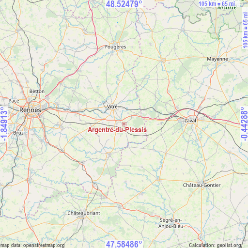
Argentré-du-Plessis GPS coordinates[2]
48° 3' 25.092" North, 1° 8' 45.636" West
| Map corner | latitude | longitude |
|---|---|---|
| Upper-left | 48.52479°, | -1.84913° |
| Center: | 48.05697°, | -1.14601° |
| Lower-right: | 47.58486°, | -0.44288° |
| Map W x H: | 104.5×104.5 km | = 64.9×64.9mi |
| max Lat: | 51.07786° ⇑39.7% North |
| Argentré-du-Plessis: | 48.05697° |
| min Lat: | ⇓60.3% South 41.3874° |
| min Long | Argentré-du-Pl | max Long |
| -5.08615° | -1.14601° | 9.52242° |
| W 10.4%⇐ | ⇒89.6% E |
Elevation
Elevation of Argentré-du-Plessis is 101 m = 331 ft, and this is 92.7 m = 304 ft below average elevation for this country.
| Max E: |
2333 m = 7654 ft | 60.4% |
| Avg. | 193.7 m = 635 ft | |
| Argentré-du-Plessis | 101 m = 331 ft | |
Min E: |
-1 m = -3 ft | 39.6% |
See also: France elevation on elevation.city.
Geographical zone
Argentré-du-Plessis is located in North temperate zone (between Tropic of Cancer and the Arctic Circle). Distance of this North polar circle is 2057.7 km =1278.6 mi to North.| Distance of | km | miles | from Argentré-du-Plessis |
|---|---|---|---|
| North Pole | 4663.6 | 2897.8 | to North |
| Arctic Circle | 2057.7 | 1278.6 | to North |
| Tropic Cancer | 2737.5 | 1701 | to South |
| Equator | 5343.4 | 3320.2 | to South |


Nearby cities:
15 places around Argentré-du-Plessis: (largest is in red/bold)
• Brielles
6.8 km =4.2 mi,  142°
142°
• Bréal-sous-Vitré
8.1 km =5 mi,  50°
50°
• Cuillé
9.8 km =6.1 mi,  168°
168°
• Domalain
9.9 km =6.2 mi,  226°
226°
• Erbrée
4.8 km =3 mi,  19°
19°
• Gennes-sur-Seiche
7.8 km =4.8 mi, 167°
• La Gravelle
9.8 km =6.1 mi,  79°
79°
• Le Pertre
8.5 km =5.3 mi,  107°
107°
• Mondevert
4.5 km =2.8 mi, 49°
• Saint-Cyr-le-Gravelais
9.2 km =5.7 mi, 105°
• Saint-Germain-du-Pinel
5.2 km =3.2 mi,  197°
197°
• Torcé
9 km =5.6 mi,  272°
272°
• Vergéal
9.2 km =5.7 mi,  255°
255°
• Vitré
8.1 km =5 mi,  326°
326°
• Étrelles
3.6 km =2.2 mi,  275°
275°
Sources, notices
• [Note1] Compared only with cities in France existing in our database
• [Src1] Map data: © OpenStreetMap contributors (CC-BY-SA)
• [Src2] Other city data from geonames.org with taken over terms of usage.
• [Src3] Geographical zone / Annual Mean Temperature by Robert A. Rohde @ Wikipedia
