Domalain geodata
Domalain (Brittany) is a populated place; located in France in Europe/Paris (GMT+2) time zone. With population of 1,628 people, there are 5734 cities with bigger population in this country. Compared to other cities in France, 59.2% of cities are located further ↓South; 90.3% of cities are located further →East and 62.4% of cities have higher elevation than Domalain. Note1
Administrative division(s):
- Level 1: Brittany
- Level 2: Département d'Ille-et-Vilaine
- Level 3: Arrondissement de Fougères-Vitré
- Level 4: Domalain


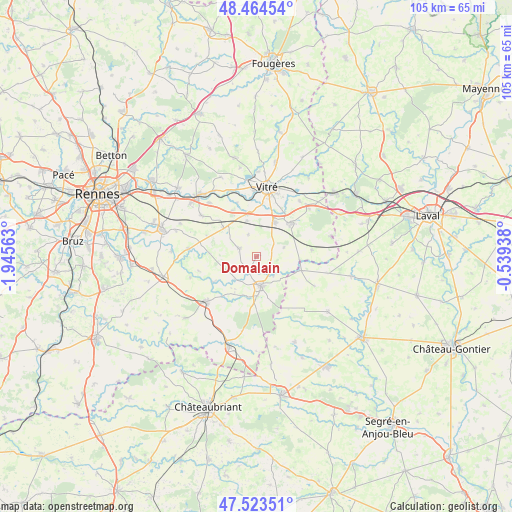
Domalain GPS coordinates[2]
47° 59' 46.212" North, 1° 14' 33" West
| Map corner | latitude | longitude |
|---|---|---|
| Upper-left | 48.46454°, | -1.94563° |
| Center: | 47.99617°, | -1.2425° |
| Lower-right: | 47.52351°, | -0.53938° |
| Map W x H: | 104.6×104.6 km | = 65×65mi |
| max Lat: | 51.07786° ⇑40.8% North |
| Domalain: | 47.99617° |
| min Lat: | ⇓59.2% South 41.3874° |
| min Long | Domalain | max Long |
| -5.08615° | -1.2425° | 9.52242° |
| W 9.7%⇐ | ⇒90.3% E |
Elevation
Elevation of Domalain is 96 m = 315 ft, and this is 97.7 m = 321 ft below average elevation for this country.
| Max E: |
2333 m = 7654 ft | 62.4% |
| Avg. | 193.7 m = 635 ft | |
| Domalain | 96 m = 315 ft | |
Min E: |
-1 m = -3 ft | 37.6% |
See also: France elevation on elevation.city.
Geographical zone
Domalain is located in North temperate zone (between Tropic of Cancer and the Arctic Circle). Distance of this North polar circle is 2064.5 km =1282.8 mi to North.| Distance of | km | miles | from Domalain |
|---|---|---|---|
| North Pole | 4670.4 | 2902.1 | to North |
| Arctic Circle | 2064.5 | 1282.8 | to North |
| Tropic Cancer | 2730.8 | 1696.8 | to South |
| Equator | 5336.7 | 3316.1 | to South |


Nearby cities:
15 places around Domalain: (largest is in red/bold)
• Argentré-du-Plessis
9.9 km =6.2 mi,  46°
46°
• Availles-sur-Seiche
5.2 km =3.2 mi,  138°
138°
• Bais
3.8 km =2.4 mi,  292°
292°
• Cuillé
9.6 km =6 mi,  107°
107°
• Gennes-sur-Seiche
8.9 km =5.5 mi,  95°
95°
• La Guerche-de-Bretagne
6.2 km =3.9 mi,  170°
170°
• Louvigné-de-Bais
8.8 km =5.5 mi,  311°
311°
• Moulins
9.7 km =6 mi,  274°
274°
• Moutiers
3.9 km =2.4 mi,  146°
146°
• Rannée
8 km =5 mi,  179°
179°
• Saint-Germain-du-Pinel
5.9 km =3.7 mi,  72°
72°
• Torcé
7.5 km =4.7 mi,  345°
345°
• Vergéal
4.8 km =3 mi,  338°
338°
• Visseiche
6.3 km =3.9 mi,  224°
224°
• Étrelles
8 km =5 mi,  26°
26°
Sources, notices
• [Note1] Compared only with cities in France existing in our database
• [Src1] Map data: © OpenStreetMap contributors (CC-BY-SA)
• [Src2] Other city data from geonames.org with taken over terms of usage.
• [Src3] Geographical zone / Annual Mean Temperature by Robert A. Rohde @ Wikipedia
